|
Geographic
Overview and Ecosystem Characteristics:
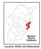
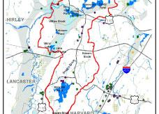
This subbasin1
predominantly lies in the community of Harvard
and Ayer, with small extensions into Bolton and Groton. Located
in the Southern New England Coastal Plains and Hills ecoregion2
of central Massachusetts, Bowers Brook flows northerly into Grove
Pond and is renamed Nonacoicus Brook downstream of this point. Flowing
out of Plowshop Pond, Nonacoicus Brook is joined by Willow Brook,
and soon thereafter empties into the Main Stem Nashua River immediately
upstream of Walker Brook's confluence with the Nashua and downstream
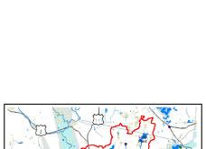
of the Devens Wastewater Treatment Facility. Routes 2, 110 and 111
pass through this subbasin and parallels Interstate 495 which is
just a few miles to the east. Two rail lines within this subbasin
intersect in Ayer. Streamflow, as in most of New England, has significant
seasonal changes3
. The southern half of the eastern boundary of this subbasin is
defined by a northeast-southwest running ridgeline.
back
to top
Land Ownership and
Land Use4
Patterns: The land-use pattern is 50%
forest (hardwood mixed with softwood) or wetland. Low-density residential
settlement as well as concentrated settlements and strip development
located near town centers and along major roads account for 16%
residential use. A relatively high percentage, 16%, of total land
area is agriculture and/or open space. Indeed, 11.9% of total impervious
surfaces5
— namely, paved areas such as streets, driveways, and parking
lots — for this subbasin indicate that issues of compromised
stormwater and other non-point sources of contaminants6
(for example: pesticides, fertilizers, oils, asphalt, pet wastes,
salt, sediment, litter and other debris) are an increasing concern.
back
to top
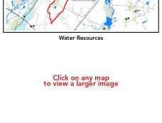
Major Water Resource
Issues: Bowers Brook is classified as
a Class B*
waterbody. Its headwaters are in an unnamed pond in Bolton just
south of the Harvard town line, whence it flows north through ¾
mile-long Bowers Spring swamp into Bare Hill Pond. Bare Hill Pond,
at 316 acres, is one of the larger waterbodies (other than Wachusett
Reservoir) in the Nashua River watershed. Bare Hill Pond is on the
303b list*,
due to elevated Phosphorus levels leading to nuisance aquatic plant,
and the Fish Toxics/Edibility list, due to elevated mercury concentrations
in its largemouth bass. As mandated by federal law, all 303b listed
waterbodies must receive a Total Maximum Daily Load (TMDL) study
and report: Bare Hill Pond was the first lake in the Commonwealth
of Massachusetts to have one completed.
Also on the 303b list are: Flannagan Pond7,
Grove Pond, Mirror Lake and Plow Shop Pond. And Grove Pond, Plowshop
Pond and Mirror Lake have been identified as having elevated mercury
in resident fish tissue as well8.
Robbins Pond in Devens is in a eutrophic state and has noxious and
invasive aquatic plants as does Plowshop Pond in Ayer. Flannagan
Pond in Ayer has noxious plants as well.
Flowing through Harvard, Bowers Brook is joined
by Cold Spring Brook just south of the Ayer town line by the Barnum
Gate into Devens. Cold Spring Brook has its headwaters in a wetland
north of Mirror Lake on Devens. The chain of hydrologically-connected
and heavily-developed ponds in Ayer (Long, Sandy and Flanagan Ponds)
drains into Bowers Brook at Grove Pond. Grove Pond abuts Plowshop
Pond, which upon discharging, and passing under roads and railroad
tracks, is called Nonacoicus Brook: a low gradient stream. Less
than a mile downstream after flowing through woods and wetlands,
Willow Brook — which has its headwaters in Robbins Pond (an
eutrophic pond*)
in Devens — joins Nonacoicus Brook which itself discharges
into the Nashua River less than ½ mile further downstream.
Both Bowers and Nonacoicus Brooks abut the former Fort Devens Military
Reservation and other developed areas, from which they receive impacted
runoff. The numerous ponds and impoundments (i.e.: Old Millpond
in Harvard) in this subbasin affect water quality as well, contributing
to low dissolved oxygen content in particular.
A large high-yield aquifer underlies a portion
of this subbasin running in a north-south direction from the Willow
and Nonacoicus Brooks intersection north of Grove-Plowshop Ponds
in Devens and Ayer to Mirror Lake in Devens. As this aquifer is
pumped by both Ayer and Devens there is concern about pre-existing
metals in Grove Pond (due to indirect withdrawal of this surface
water through induced infiltration into the valley aquifer wells9).
This area is a wellhead protection area and therefore receives greater
protection from present and future sources of pollution. An even
larger medium-yield aquifer surrounds the entirely of the high-yield
aquifer above and extends further: from just to the east of Sandy
Pond in Ayer to the Willow Brook-Shepley Hill area on Devens. Other
connecting arms of this very large medium- and high-yield aquifer
system — that underlies the Squanncook and Mainstem Nashua
Rivers — extend to the north, south and west of this subbasin's
boundary. Polluted runoff and sedimentation is an increasingly serious
issue in rapidly developing communities.
There are three NPDES*
permits in this subbasin: the Ayer Municipal Wastewater Treatment
Facility is the one major permitee with effluent discharging to
the Nashua River; CPF Inc. is a minor permitee; and Old Town Village
Apartments is a minor industrial permitee that discharges to Day
Brook, a tributary to Flanagan Pond. There are many identified areas
of concern (AOCs) from a contamination standpoint on Devens, which
include: Shepley Hill Landfill (AOCs 4,5, 8), West Rail/Industrial
zone (AOCs 32 and 43A), South Post Impact Area, Army Enclave Property
(AOC 43 G & J), site of Parker Charter School (AOC 69W), Moore
Airfield (AOC 50), Barnum Road Area (AOC 57) and Consolidation Landfill
(AOC 9 and SA 13). There is on-going long-term monitoring plans
for groundwater — also known as ground-water institutional
controls — for which the US Army is responsible for each of
the above sites.
back to top
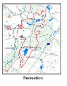
Recreation and
Priority Habitat Areas: The Department
of Environmental Protection's (DEM) 1983 Scenic Inventory Protect
identified two sections in this subbasin as contributing "distinctive"
scenic character to the entire region. Others have also identified
this area as having special agricultural character, which ought
to be protected10.
Mirror Lake in Devens is a highly-used recreational destination
and public swimming area. Grove Pond and associated Pirone Park
are locally popular recreation sites in Ayer. Bare Hill Pond is
heavily-developed around its shoreline and heavily-used by abutting
property-owners and by Harvard residents who have sole access to
the town beach (which abuts Bromfield High School) during beach
use dates. The 12 mile-long Ayer to Dunstable Rail Trail, owned
and managed by the Department of Environmental Management (DEM),
is just being constructed as a combined bicycling, walking, and
bridle trail. Its southern terminus/trailhead is in Ayer center
exactly at the terminus of a 14-mile potential Ayer to Townsend
Rail Trail.
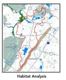
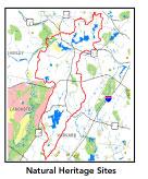
Nearly all of Bowers Brook from Pine Hill in
Harvard north to Grove Pond and including some of its tributaries
is considered to be a Natural Heritage and Endangered Species Project
(MA NHESP) BioMap core area11
as is all of the Snake Hill-Long Pond area. There are three state-designated
MA NHESP Rare Wetlands Wildlife Habitat areas in this subbasin,
which are designated Priority Habitat areas as well. These are:
1) a wetland through which Bowers Brook flows just east of the Route
2 interchange at Route 110/111 and west of Poor Farm Road; 2) along
Cold Spring Brook by Barnum Road to the east of Robbins Pond; and,
3) along all of Nonacoicus Brook to the north of West Main St. including
the mouth of Willow Brook. A fourthMA NHESP Priority Habitat area
is located between Shepley Hill and Plowshop Pond north of the railroad
tracks.
Snake Hill-Long Pond is the one habitat protection
focus area identified in the Nashua River Habitat Assessment
Report (MAS, 2000), encompassing the northernmost portion down
to Ayer center. Straddling the Ayer-Groton border, this area contains
a diverse combination of uplands adjacent to extensive wetlands.
Powerline and gas rights-of-way provide movement corridors and the
network of swamps and marshy areas are likely important undisturbed
breeding habitat for multiple species. The network also provides
dispersal routes between the large ponds in the area — Flannagan
and Sandy Ponds to the southwest, Spectacle Pond to the southeast,
and Knops Pond and Lost Lake to the northeast. As very little of
the area is protected land, habitat conservation priorities should
focus here and especially unprotected lands adjacent to Long Pond.
Snake Hill-Long Pond area is also the southeastern most section
within the proposed Petapawaug Area of Critical Environmental Concern
(ACEC)12
nomination. Likewise, the Nonacoicus Brook-Grove
and Plowshop Ponds section of Ayer is the southwestern most section
within the proposed Squannassit ACEC nomination.
back to top
Resource Protection Goals
and Recommended Actions
GOAL: Protect wildlife habitat
and migration corridors in the subbasin.
- Sponsor local events to raise public understanding
about native wildlife and the impacts of development patterns
on ecosystem and habitat integrity.
- Work with local conservation commissions to gain
their backing of natural resource and habitat inventories.
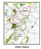
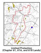
GOAL: Protect high-priority open space, vistas,
and community character in the subbasin.
- Encourage the use of MA Executive Order 418*
funding for Open Space and Resource Protection Plans for each
Massachusetts community in this subbasin.
- Conduct public education sessions to promote local
passage of Community Preservation Act*.
- Work toward ideal of at least 25-50% protected
open space in each municipality. Determine which Chapter 61, 61A
and 61B properties to pursue Right of First Refusal*
options on if the opportunity arises.
- Work with municipal officials to develop subdivision
standards that require proponents to devote at least 50% of land
(not including already undevelopable wet or steep land) for open
space conservation and encourage mixed-use development and cluster
zoning by-right bylaws.
GOAL: Increase recreational opportunities throughout
the subbasin.
- Survey invasive plant infestation and conduct spot
treatment to control spread of noxious plants at Flannagan Pond,
Grove Pond, Long Pond , Mirror Lake, Plowshop Pond and Robbins
Pond.
- Implement restoration plan for Bare Hill Pond as
detailed in Diagnostic/Feasibility Study (1987) and TMDL Final
Report (2000) including non-point source (NPS) watershed field
survey; lake association to organize and establish septic inspection
program and annual septic pumping for all lakeside homeowners;
as part of erosion control ordinance help Town Department of Public
Works (DPW) to reduce erosion from town roadways and runoff sources;
Town Conservation Commission to ensure minimized erosion from
construction; establish vegetated buffer around lake; establish
phosphorus use program and encourage use of non-phosphorus lawn
fertilizer; and, phased implementation of a berm/uptake system
to reduce nutrient loading.
- Educate the public and municipal departments (especially
DPWs) on efforts relating to invasive species identification and
removal.
- Investigate the feasibility of establishing an
Ayer to Townsend Rail Trail along the abandoned B & M Greenville
line which begins in Ayer center.
- Support implementation efforts of the Devens Open
Space and Recreation Plan, the Devens Regional Trails Initiative,
and the Squannassit Regional Trails Initiative.
- Support confirmation of upcoming Squannassit and
Petapawag Areas of Critical Environmental Concern (ACEC) nominations.
GOAL: Improve water quality in the subbasin.
- Help develop and disseminate Best Management Practices
(BMPs) for small-scale, hobby type agricultural operations.
- Identify any Water Management Act (WMA) withdrawals
in this subbasin.
- Identify underground storage tanks (USTs) and work
to have them removed.
GOAL: Reduce potential negative effects of some
development in this subbasin.
- Help local volunteer board members responsible
for development and land-use rulemaking and enforcement get technical
assistance and information regarding techniques to control/guide
land use and development balanced with adequate resource protection
(e.g., Citizens Planner Training Collaborative13
workshop offerings).
- Increase or establish staff hours of municipal
conservation agents to more effectively monitor construction sites
runoff and assist with the preparation of bylaws such as erosion-sedimentation
controls.
back to top
*
.
back
to top
|