|
Geographic
Overview and Ecosystem Characteristics:
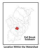
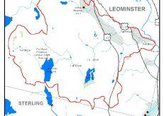
This subbasin1
is completely within the City of Leominster. Located
in the Southern New England Coastal Plains ecoregion2
of central Massachusetts, this area drains easterly
into the North Nashua River downstream of the West Fitchburg
Wastewater Treatment Facility and just upstream of the
USGS gauging station. Streamflow, as in most of New
England, has significant seasonal changes3.
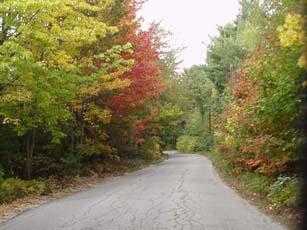
This subbasin begins at higher elevations along the
ridgeline above the Grandview Country Club between Long,
Bayberry and Rocky Hills. Routes 12 and117 pass through
this subbasin.
back
to top
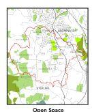
Land Ownership
and Land Use4
Patterns: The land-use pattern
is 47% forest (hardwood mixed with softwood) or wetland.
This is one of the lowest percentages of forestland
in the entire Nashua River watershed yet understandable
given its immediate proximity to downtown urban Leominster.
High-density residential settlement as well as suburban
subdivisions and strip development throughout the subbasin
account for a total of 26% residential. 11% of the total
area is open land. Commercial operations, industry and
other developed land uses are numerous.
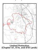
As for permanently protected open space,
a portion of this subbasin is owned by the City of Leominster
as designated municipal water supply lands — Fall
Brook Reservoir and Morse Reservoir —
and as city parks such as Barrett Pond. The area around
the mouth of Fall Brook is Department of Environmental
Management's Johnny Appleseed State Park. Lincoln Woods
is a small Massachusetts Audubon Society holding in
this subbasin.
A rather high percentage (20.1%)
of total impervious surfaces5
— namely, paved areas such as streets, driveways,
and parking lots — for this subbasin indicates
that issues of compromised stormwater and other non-point
sources of contaminants (for example: pesticides, fertilizers,
oils, asphalt, pet wastes, salt, sediment, litter and
other debris) are a pressing concern.
back
to top
Major
Water Resource Issues: There
is a medium-yield aquifer underlying the northern divide
of this subbasin as well as a smaller one underlying
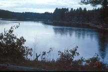
Lake Samoset. Major waterbodies in this subbasin include:
Fall Brook Reservoir, Lake Samoset, and Barrett Pond.
The latter two contain noxious and non-native plants.
Fall Brook proper is classified as a Class B waterbody.
In this subbasin there are no wastewater treatment facilities,
no water withdrawal permitees, and no NPDES*
permitee.
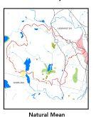
Based on recent findings in an Hydrologic
Analysis (inflow/outflow) by Camp, Dresser, Mckee, under
contract with EOEA for the Massachusetts Watershed Initiative
Nashua Team, the Fall Brook sub-basin is currently under
a medium level of stress. Looking ahead to the year
2020, Fall Brook remains under a medium level of stress.
This means that the net 7Q10 outflow from the sub-basin
equals or exceeds the estimated natural 7Q10. 7Q10 is
the lowest consecutive 7 day streamflow that is likely
to occur in a ten year period in a particular river
segment.
back
to top
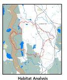
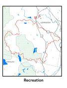
Recreation
and Priority Habitat Areas: Barrett
Pond (a.k.a. Chestnut Street Pond) had been a popular
local recreation destination when the pond was a viable
public swimming facility. Conditions at Barrett Pond
have deteriorated dramatically — due to uncontrolled
vegetative growth, excessive sedimentation, high turbidity
and algae blooms — and safety is a major issue.
There are two state-designated Natural Heritage and
Endangered Species Project (MA NHESP) Rare Wetlands
Priority Habitat area: one of which includes Lake Samoset.
The one core area identified in the Nashua River
Habitat Assessment Report (MAS, 2000), which encompasses
the western part of this subbasin, is the Notown Reservoir
area. The western most ridge consisting of Long, Bayberry
and Rocky Hills provides an upland connection to the
south and thus should be considered a recommended priority
area for land conservation.
back
to top
Resource
Protection Goals and Recommended Actions
GOAL: Protect wildlife
habitat and migration corridors in the subbasin.
- Land protection efforts to focus on
undeveloped eastern shoreline on Fall Brook Reservoir
and parcels by Lake Samoset.
- Sponsor local events to raise public
understanding about native wildlife and the impacts
of development patterns on ecosystem and habitat integrity.
- Work with local conservation commissions
to gain their backing of natural resource and habitat
inventories.
GOAL: Protect high-priority open space,
vistas, and community character in the subbasin.
- Encourage the use of MA Executive Order
418* funding
for Open Space and Resource Protection Plans for each
Massachusetts community in the Fall Brook subbasin.
- Conduct public education sessions to
promote local passage of Community Preservation Act*.
- Work toward ideal of at least 25-50%
protected open space in each municipality by supporting
the City of Leominster's stated intention of protecting
further watershed properties. Encourage more collaborative
open space conservation projects between the City,
the State, The Trustees of Reservations, the Leominster
Land Trust, and the public (i.e.: Sholan Farm).
- Work with municipal officials to develop
subdivision standards that require proponents to devote
at least 50% of land (not including already undevelopable
wet or steep land) for open space conservation and
encourage mixed-use development and cluster zoning
by-right bylaws.
GOAL: Increase recreational opportunities
throughout the subbasin.
- Support City of Leominster's proposal
to restore Barrett Pond Park and its watershed.
- Improve canoeing, fishing, and swimming
opportunities by removing weeds from water bodies.
- Educate the public and municipal departments
(especially Public Works Depts) on efforts relating
to invasive species identification and removal.
GOAL: Improve water quality in the
subbasin.
- Assist Leominster with its Clean Water
Act-mandated MS-4 Phase II Stormwater requirements*
This municipality will be required to obtain permits
to reduce impacts to the receiving streams through
the development of Best Management Practices (BMPs)*,
elimination of cross-connections and significant public
education. CSO controls and the development of a long-range
control plan will be required.
- Help develop and disseminate Best Management
Practices for small-scale, hobby type agricultural
operations.
- Survey invasive plant infestation
and conduct spot treatment to control spread on Lake
Samoset and Barrett Pond. Also, conduct assessment
of 303d list status for Barrett Pond.
- Inventory, monitor and improve stormwater
drainage structures.
- Identify underground storage tanks
(USTs) and work to have them removed.
GOAL: Reduce negative effects of development
in this subbasin.
- Review the turf maintenance practices
of the area golf courses up gradient of Fall Brook
Reservoir to determine potential non-point source
pollution from fertilizer use.
- Help local volunteer board members
responsible for development and land-use rulemaking
and enforcement get technical assistance and information
regarding techniques to control/guide land use and
development balanced with adequate resource protection
(e.g., Citizens Planner Training Collaborative6
workshop offerings).
- Increase or establish staff hours of
municipal conservation agents to more effectively
monitor construction sites runoff and assist with
the preparation of bylaws such as erosion-sedimentation
controls.
back
to top
.
|