|
Geographic
Overview and Ecosystem Characteristics:
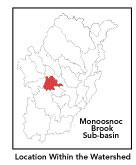
This subbasin1
is primarily within the City of Leominster in addition to a portion
in the City of Fitchburg. Located in the "fuzzy" zone
between the Southern New England Coastal Plains and the Upper Worcester
Plateau ecoregions2
of central Massachusetts, this area drains easterly into the North
Nashua River downstream of the West Fitchburg Wastewater Treatment
Facility and just upstream of the USGS gauging station. Streamflow,
as in most of New England, has significant seasonal changes3.
The western boundary of this subbasin is the Palmer and Ball Hills
ridgeline. An even more prominent ridgeline runs through the heart
of this subbasin: the North and South Monoosnoc Hills. Route 2 passes
through this subbasin as does a short stretch of Route 12.
back to top
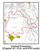
Land Ownership and
Land Use4 Patterns:
The land-use pattern is 71% forest (hardwood
mixed with softwood) or wetland. Low, medium, and high-density residential
settlement as well as suburban subdivisions and strip development
throughout the subbasin account for a total of 14% residential.
5% of the total area is agricultural or open land. Commercial operations,
industry and other developed land uses are numerous.
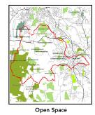
As for permanently protected open space, a portion of this subbasin
is owned by the City of Fitchburg as Coggshell Park. The City of
Leominster owns much land for watershed protection and other municipal
purposes. The area to the southwest of Notown Reservoir is Department
of Environmental Management's Leominster State Forest.
A high percentage (13.2%) of total impervious
surfaces5
— namely, paved areas such as streets, driveways, and parking
lots — for this subbasin indicates that issues of compromised
stormwater and other non-point sources of contaminants (for example:
pesticides, fertilizers, oils, asphalt, pet wastes, salt, sediment,
human litter and other debris) are a pressing concern.
back to
top
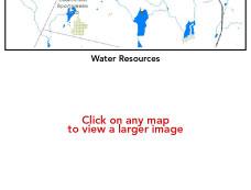
Major Water Resource
Issues: There
is a medium-yield aquifer underlying the northern divide of this
subbasin as well as a smaller one underlying Lake Samoset. Major
waterbodies in this subbasin include: Distributing, Haynes, Morse
and Notown Reservoirs; Mirror Lake; and Pierce and Rockwell Ponds.
Pierce Pond is on the 303(b)* list of impaired waterbodies as it
contains noxious plants. Rockwell Pond is considered eutrophic.
Monoosnoc Brook proper is classified as a Class
B waterbody. In this subbasin there are no wastewater treatment
facilities, one water withdrawal permitee — B.F. Goodrich Company
is permitted to withdraw 0.12 MGD of groundwater — and one
NPDES permitee: again Goodrich, a minor industrial discharger of
non-contact cooling water to Monoosnuc Brook. In 1997 and 1998 the
NRWA conducted water quality monitoring at two stations on Monoosnuc
Brook. No major water quality problems were identified.
Based on recent findings in an Hydrologic Analysis
(inflow/outflow) by Camp, Dresser, Mckee, under contract with EOEA
for the Massachusetts Watershed Initiative Nashua Team, the Monoosnoc
sub-basin is currently under a medium level of hydrological stress
due to more water being exported from the basin (via water supply
withdrawals and sewers) than comes into the basin via precipitation
and other means. But it is bordering on a high level of stress.
Looking ahead to the year 2020, the Monoosnoc is placed under a
high level of stress.
This means that the net 7Q10 outflow from the
sub-basin equals or exceeds the estimated natural 7Q10. 7Q10 is
the lowest consecutive 7 day streamflow that is likely to occur
in a ten year period in a particular river segment under current
conditions. And in the 2020 projection for a high stress level,
the net average August outflow from the sub-basin equals or exceeds
the estimated natural August average flow.
back to
top
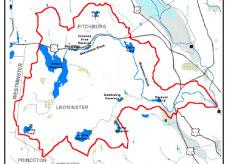
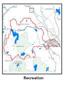
Recreation
and Priority Habitat Areas: Coggshall
Park is a major recreational destination in this subbasin. Nearly
5 miles of the long-distance Mid-state Trail passes through this
subbasin; although it may be noted that there are no trail easements
thereon. The trail system through the Monoosnoc Hills is particularly
good. Monoosnoc Greenway Project has established a walkway along
the brook.
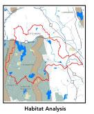
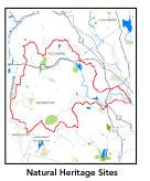
There are three state-designated Natural Heritage
and Endangered Species Project (MA NHESP) Rare Wetlands Priority
Habitat areas: 1) Haynes Reservoir; 2) an area that is between Notown
Reservoir and Goodfellow Pond; and 3) just to the southwest of Pierce
Pond. The one core area identified in the Nashua River Habitat
Assessment Report (MAS, 2000), which encompasses fully half
of this subbasin, is the Notown Reservoir area. The Ball-Palmer
and Monoosnoc Hills ridgelines provide upland connections to the
south and thus should be considered a priority area for land conservation.
Of primary importance are privately-owned undeveloped parcels abutting
the southwest side of Notown Reservoir.
back to
top
Resource Protection
Goals and Recommended Actions
GOAL: Protect wildlife habitat
and migration corridors in the subbasin.
- Land protection efforts to focus on eastern shoreline
of Notown Reservoir and Haynes Reservoir.
- Monitor potential development of the Palmer Hill
area.
- Sponsor local events to raise public understanding
about native wildlife and the impacts of development patterns
on ecosystem and habitat integrity.
- Work with local conservation commissions to gain
their backing of natural resource and habitat inventories.
GOAL: Protect high-priority open space, vistas,
and community character in the subbasin.
- Further protect Monoosnoc Hills
- Encourage the use of MA Executive Order 418*
funding for Open Space and Resource Protection Plans for each
Massachusetts community in this subbasin.
- Conduct public education sessions to promote local
passage of Community Preservation Act*.
- Work toward ideal of at least 25-50% protected
open space in each municipality by supporting the City of Leominster's
stated intention of protecting further watershed properties. Encourage
more collaborative open space conservation projects between the
City, the State, The Trustees of Reservations, the Leominster
Land Trust, and the public (i.e.: Sholan Farm).
- Work with municipal officials to develop subdivision
standards that require proponents to devote at least 50% of land
(not including already undevelopable wet or steep land) for open
space conservation and encourage mixed-use development and cluster
zoning by-right bylaws.
GOAL: Increase recreational opportunities throughout
the subbasin.
- Improve canoeing, fishing, and swimming opportunities
by removing weeds from water bodies.
- Educate the public and municipal departments (especially
Public Works Depts) on efforts relating to invasive species identification
and removal.
- Enhance passive use of watershed lands (walking,
trails, e.g.)
GOAL: Improve water quality in the subbasin.
- Assist Fitchburg and Leominster with its Clean
Water Act-mandated MS-4 Phase II Stormwater requirements*.
These municipalities will be required to obtain permits to reduce
impacts to the receiving streams through the development of Best
Management Practices (BMPs)*,
elimination of cross-connections and significant public education.
CSO controls and the development of a long-range control plan
will be required.
- Survey invasive plant infestation and conduct spot
treatment to control spread on Pierce Pond.
- Monoosnoc Brook from Simonds Pond to its outfall
needs more sampling given BF Goodrich discharge.
- Identify Water Management Act (WMA)*
withdrawals. Evaluate compliance with registration and/or permit
limits. Determine potential impacts of withdrawals on streamflow/habitat
and work toward restoring natural flow regimes where feasible.
- Inventory, monitor and improve stormwater drainage
structures.
- Identify underground storage tanks (USTs) and work
to have them removed.
GOAL: Reduce negative effects of development in
this subbasin.
- Help local volunteer board members responsible
for development and land-use rulemaking and enforcement get technical
assistance and information regarding techniques to control/guide
land use and development balanced with adequate resource protection
(e.g., Citizens Planner Training Collaborative6
workshop offerings).
- Increase or establish staff hours of municipal
conservation agents to more effectively monitor construction sites
runoff and assist with the preparation of bylaws such as erosion-sedimentation
controls.
back to
top
*
See glossary.
|