|
Geographic
Overview and Ecosystem Characteristics:
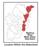
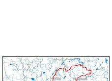
This north to south running, long and narrow subbasin
1
lies within portions of the following communities: Bolton,
Groton, Harvard, Lancaster, Pepperell and Shirley, Massachusetts
and Hollis and Nashua, New Hampshire. Located in the Southern
New England Coastal Plains and Hills ecoregion of central
Massachusetts, the Mainstem Nashua River flows into the Merrimack
River in Nashua, New Hampshire. The Mainstem Nashua River
officially begins in Lancaster at the confluence of its two
major tributaries: the North and South Nashua Rivers. Routes
2, 2A, 110, 111, 113, 117, 119 and 225 cross through this
subbasin. A notable ridgeline in this subbasin runs from Shipley
Hill to Mt. Lebanon in Pepperell.
The Southern New England Coastal Plains
and Hills ecoregion is an area with generally similar soils,
vegetation, shape of the land, and especially, cool climate
and bedrock geology (glacial tills and outwash deposits).
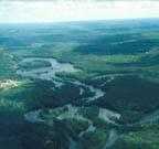
The river maintains a good flow rate until it deepens and
slows near its mouth. Streamflow, as in most of New England,
has significant seasonal changes 2.
It is interesting to note that this subbasin is unusual in
having once been the site of a glacial lake (Lake Nashua)
that flowed southward toward the Worcester area. At the end
of the last Ice Age, its direction reversed, creating the
Nashua River as we know it today. The Mainstem now flows northward
from its impoundment at Wachusett Reservoir to the Merrimack
River in Nashua, New Hampshire. In contrast, all of the river's
major tributaries flow in a southeasterly direction, turning
sharply as they join the less turbulent Mainstem: which makes
it more susceptible to oxygen depletion from pollution. This
vulnerability is compounded by four dams along its length.
back to
top
Land Ownership
and Land Use3
Patterns: The land-use pattern is
64% forest (hardwood mixed with softwood) or wetland. Low-density
residential settlement as well as concentrated settlements
and strip development located near town centers and along
major roads account for a total of 13% residential. Approximately
7% of total land area is agriculture and/or open space. Although
these land-use estimates do not suggest a high risk for potentially
contaminated runoff, the land-use along the Mainstem Nashua
River in Ayer, MA and Nashua, NH — as well as the Fitchburg-Leominster
area upstream along the North Nashua River — is primarily
high-density residential, industrial, and commercial. Such
land-use types have a much greater potential to negatively
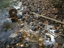
impact water quality due to urban runoff/storm sewers.
Indeed, a low percentage (9.1%) of total
impervious surfaces4
— namely, paved areas such as streets, driveways, and
parking lots — for this subbasin indicates that issues
of compromised stormwater and other non-point sources of contaminants
(for example: pesticides, fertilizers, oils, asphalt, pet
wastes, salt, sediment, litter and other debris) are not an
immediate pressing concern. Nonetheless, primary pollutants
of concern in stormwater are: suspended solids, nutrients,
metals, oil and grease, temperature and bacteria. The sources
of bacteria in urban settings (i.e.: Ayer, Nashua) are typically
human litter and animal waste left on driveways, lawns, commercial
and residential streets, parking lots and rooftops. Furthermore,
increasing urbanization leads to diminished groundwater recharge
and to declining stream flow as well as stream channel widening
and downcutting.
back to
top
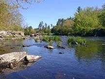
Major Water
Resource Issues: The mainstem Nashua
River is classified as a Class B*
waterbody, and a warm water fishery. The Mainstem Nashua River
shows high phosphorus levels and some high bacteria counts.
Treated wastewater accounts for about 30% of the Nashua River's
summertime flow, making the river vulnerable to malfunctions
at treatment facilities and other wastewater dischargers.
Combined sewer overflows (CSOs) — a type of point-source
pollution — which carry both wastewater and stormwater
originating in upstream urban areas of the larger Nashua River
watershed, negatively impact the Mainstem Nashua River. Non-point
source pollution — polluted runoff and sedimentation
— is an increasingly serious issue in rapidly developing
communities.
Major waterbodies in this subbasin include
Pepperell Pond, which is classified as hypereutrophic, excessively
turbid, and, containing low dissolved oxygen, excessive nutrients
(otherwise known as "organic enrichment") and noxious
non-native plants. As metals (Hg) have been detected, there
is a fish consumption advisory. This stretch of the Mainstem
River -from the confluence with the Squannacook River to Pepperell
Dam — is being considered for inclusion on the MA DEP
303(d)* list of impaired waters.
According to the 1998 Nashua River Watershed
Report Card:
- The Nashua River Mainstem from the
confluence of the North Nashua River to the Ice House Dam
in Shirley/ Ayer/Harvard is rated as non-supportive of biology,
nutrients, toxicity, and sediment and was assessed as supportive
for the primary and secondary contact uses (swimming and
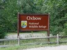
boating, respectively). This 10.6 mile reach encompasses
the Oxbow National Wildlife Refuge.
- From the Ice House Dam to the intersection
with the Squannacook River it is rated as non-supportive
of biology, nutrients, toxicity, sediment, swimming and
boating because of elevated fecal coliform bacteria levels
and degraded aesthetic quality (objectionable turbidity
and sewage odors) due to known municipal point sources.
Downstream from this confluence to Pepperell Pond neither
of the recreational uses was assessed.
- Throughout the 3.5 mile reach of the
Pepperell Pond it is rated as non-supportive of biology,
chemistry, nutrients, fish tissue, boating and swimming.
From Pepperell Pond to the Nissitissit River it is rated
as non-supportive of biology, nutrients and swimming; partially-supportive
of boating due to dense macrophyte cover and excessive turbidity;
and on alert status for hydrology.
- From the Nissitissit River to the New
Hampshire line it is rated as non-supportive of swimming
— because of elevated levels of fecal coliform bacteria
possibly from illicit sewer connections — and partially
supportive of biology and nutrients.
The two major municipal effluent National
Pollutant Discharge and Elimination System (NPDES)*
permits in the subbasin are for the Ayer WWTF and the MCI
Shirley WWTF, while the Pepperell WWTF is considered to be
a minor municipal permitee. Additional NPDES minor industrial
discharge permitees are: Groton School, Indeck Pepperell Power
Association, and Bemis Company, while Pepperell Paper Company
is considered a major industrial permitee. Pepperell Paper
Company is the one registered water withdrawals permitee.
Finally, and not surprisingly, there are water quality issues
in Nashua, NH — the most urbanized population center
in this subbasin — where point sources of pollution are
five Combined Sewer Overflows (CSO) releasing, of particular
concern, floatables and bacteria.
back to
top
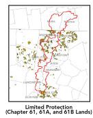
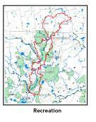
Recreation
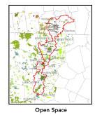
and Priority Habitat Areas: There
is a considerable amount of permanently protected open space
in this subbasin. Partially this is a result of decades of
conservation efforts on the part of the Nashua River Watershed
Association and the municipal greenway committees, which have
focused on riparian corridor protection. The largest individual
open space holdings in Massachusetts are: Oxbow National Wildlife
Refuge (NWR), J. Harry Rich State Forest, Rich Tree Farm,
Throne Hill, Bolton Flats Wildlife Management Area (WMA),
Ayer Game Farm, Groton Town Forest, and Groton Place in addition
to many conservation commission and other assorted local land
trust parcels. Fruitlands Museum and Groton School are large
holdings with only limited protection. Much of this subbasin
is classified as either distinctive or noteworthy in the Massachusetts
Landscape Inventory (1983), given its orchards and farmland
rolling scenery. In New Hampshire the largest individual open
space holdings include: Mine Falls Park in Nashua, Town of
Hollis Conservation Lands, Spaulding Farm Open Space, and
assorted conservation easement and large subdivision open
space set-asides.
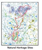
This subbasin's fifteen state-designated
MA Natural Heritage and Endangered Species Project (NHESP)
Priority Habitat areas include all of the Rare Wetlands Wildlife
sites listed in the footnote below5
plus: a site within the J. Harry Rich State Forest; two nearby
sites on the South Post-Devens6;
two nearly adjacent sites to the east of Moore Airfield in
Ayer; and, along the east bank of the Nashua River on Devens
just north of Route 2 Jackson Road exit.
Two medium priority habitat protection
focus area identified in the Priority Sites for Wildlife
Habitat Protection in Pepperell, Massachusetts (MAS, 2001)
are the Nissitissit Hills and at Bancroft Brook east of Shipley
Hill in Pepperell. Three high priority habitat protection
focus areas are:
- the Nashua River area from the east
of the Nissitissit Hills to Four Corners in East Pepperell;
- the Nashua River Oxbows opposite the
J. Harry Rich State Forest to the east of Route 111 and
north of Route 119; and,
- the Throne7
in West Groton and Pepperell, which is special for the extent
of undeveloped upland, and the number of vernal pools it
harbors on its upper slopes.
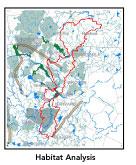
Nashua River-Mulpus Brook is the
one habitat protection corridor identified in the Nashua
River Habitat Assessment Report (MAS, 2000). There are
four habitat protection focus areas identified in the Report.
- Nashua River-Mulpus Brook.
- Hound Meadow Hill-Hawk Swamp:
the lightly developed northwestern corner of Dunstable important
for its 2.5 miles of undeveloped riverbank along the Nashua
River.
- Squannacook Hill: featuring
the confluence of the Squannacook and Nashua Rivers, this
focus area is important for its floodplain forest habitat,
extensive wetlands with adjacent uplands, as a riparian
corridor buffer, and as a stepping stone for wildlife movement
north from the Oxbow NWR.
- J. Harry Rich State Forest:
the Nashua River as it passes through this focus area has
been identified by Nashua River Watershed Association aquatic
experts as important habitat for birds, fish, and turtles8.
Devens South Post is identified in the
Nashua River Habitat Assessment Report (MAS, 2000)
as the one core habitat area in this subbasin. This large
focus area is a wildlife habitat anchor in the east-central
section of the watershed. Located in Lancaster, Harvard, and
Bolton, the protected and largely trail-less Oxbow NWR and
Bolton Flats WMA, and restricted-public-access Devens South
Post9
create what could be the largest, least human-impacted habitat
in the watershed.
More than half of this subbasin (in the
Massachusetts portion) is considered to be a Natural Heritage
and Endangered Species Project (MA NHESP) BioMap10
core area including such areas as: the Throne; Devens: the
North, South and Middle Posts; Morse, Walker and Reedy Meadow
Brooks riparian corridors, etc.
A very small portion of the Central Nashua
River Valley Area of Critical Environmental Concern11
(ACEC) — currently the only ACEC in the Nashua River
watershed — falls within the northern section of this
subbasin in the Five Corners neighborhood of South Lancaster.
The entire northern half of this subbasin (within Massachusetts)
falls within the proposed Petapawag Area of Critical Environmental
Concern (ACEC) nomination.
back to
top
Resource Protection
Goals and Recommended Actions:
GOAL: Protect wildlife
habitat and migration corridors in the subbasin.
- Land protection efforts along the west bank
of the Nashua River across from J. Harry Rich State Forest
and a connector between Bolton Flats WMA and Oxbow NWR.
- Pursue continued and long-term appropriate
management of the Ayer Game Farm, Groton Town Forest and
Devens South Post in ways that are conducive to maintaining
wildlife habitat.
- Sponsor local events to raise public understanding
about native wildlife and the impacts of development patterns
on ecosystem and habitat integrity.
- Work with local conservation commissions
to gain their backing of natural resource and habitat inventories.
GOAL: Protect high-priority open space, vistas,
and community character in the subbasin.
- Encourage the use of MA Executive Order 418*
funding for Open Space and Resource Protection Plans for
each Massachusetts community in this subbasin.
- Conduct public education sessions to promote
local passage of Community Preservation Act*.
- Support efforts of the Squannassit Regional
Reserve Initiative*
(facilitated by the NRWA) and the Squannassit ACEC nomination
which encompasses much of this subbasin.
- Work toward ideal of at least 25-50% protected
open space in each municipality. Determine which Chapter
61, 61A and 61B properties to pursue Right of First Refusal*
options on if the opportunity arises.
- Work with municipal officials to develop
subdivision standards that require proponents to devote
at least 50% of land (not including already undevelopable
wet or steep land) for open space conservation and encourage
mixed-use development and cluster zoning by-right bylaws.
GOAL: Increase recreational opportunities
throughout the subbasin.
- Survey water chestnut invasive plant infestation
and control spread of noxious aquatics at Pepperell Pond.
- Educate the public and municipal departments
(especially Public Works Depts) on efforts relating to invasive
species identification and removal.
GOAL: Improve water quality in the subbasin.
- Considered Pepperell Pond for inclusion on
the MA DEP 303(d)*
list of impaired waters.
- Identify sources of fecal coliforms and other
contaminants. Identify all water withdrawals.
- Track proceedings of Ayer's wastewater management
plan and Groton School upgrading of their effluent discharge
system as mandated by DEP enforcement orders.
- Determine locations of combined sewer overflows
(CSOs) in Nashua. Continue to track progress of CSO abatement
activities. Conduct additional dry and wet weather fecal
coliform bacteria monitoring in most impacted segments of
Mainstem Nashua River to identify potential sources of pathogens
and other contaminants.
- Encourage Best Management Practices (BMPs)
at area trailer parks and golf courses.
- Identify and rectify problems with factory
floor drains that may still discharge pollutants to waterways
(versus to discharging to tight tanks or sewer systems).
- Evaluate current status of stormwater runoff
controls (i.e., permits, pollution prevention plans, BMPs)
in particular, at Pepperell Paper Company and Indeck Pepperell
Power Company. Inventory, monitor and improve stormwater
drainage structures.
- Assist Groton with its Clean Water Act-mandated
MS-4 Phase II Stormwater*
requirements.
- Implement recommended BMPs from TMDL-urban
runoff.
- Identify any other WMA withdrawals in the
subwatershed of this segment of the Nashua River. Evaluate
any potential impacts of WMA withdrawals on streamflow/habitat.
- Continue to monitor nutrient concentrations
in most impacted segments of the Mainstem Nashua River and
evaluate the Nashua River Basin major municipal NPDES facilities
(i.e.: WWTFs) compliance with their effluent total phosphorous
(TP)*
limits. These municipal permits will include total phosphorus
limits of 1.0 mg/L to reduce nutrient inputs to the Nashua
River/ Pepperell Pond.
- Conduct SMART12
monitoring, and instream and chronic toxicity testing.
- Identify underground storage tanks (USTs)
and work to have them removed.
GOAL: Reduce potential negative effects of
some development in this subbasin.
- Require that substandard septic systems of
homes on Pepperell's Yale St. ("The Ivy's") neighborhood
are brought into compliance (through inspections at point
of sale).
- Help local volunteer board members responsible
for development and land-use rulemaking and enforcement
get technical assistance and information regarding techniques
to control/guide land use and development balanced with
adequate resource protection (e.g., Citizens Planner Training
Collaborative13 workshop
offerings).
- Increase or establish staff hours for municipal
conservation agents to more effectively monitor construction
sites runoff and assist with the preparation of bylaws such
as erosion-sedimentation controls.
back
to top
*
See glossary.
|