|
Geographic
Overview and Ecosystem Characteristics:
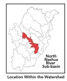
This subbasin1
lies in the communities of Fitchburg,
Leominster and Lancaster with a very small part extending
into Lunenburg. Located in the Southern New England Coastal
Plains and Hills ecoregion2
of central Massachusetts, this area drains into the South
Nashua River at "Meeting of the Rivers" in Lancaster
to form the Mainstem Nashua River.
The North Nashua River
begins at the confluence of Whitman River and Flag Brook in
West Fitchburg. It flows southeasterly through the cities
of Fitchburg and Leominster, where it is affected by urban
influences, including ten dams. Route 2 travels through the
center of this subbasin and Routes 31, 2A, 70, 117 pass through
a portion as well. The Fitchburg-Boston Commuter Conrail line
crosses the subbasin.
Streamflow, as in most of New England,
has significant seasonal changes3
. Baker, Falulah, McGovern, Ponakin, Punch and Spectacle Brooks
are feeder streams to North Nashua River. [Some of these feeder
streams are considered to be separate subbasins and are discussed
in their own subbasin narratives elsewhere in this plan.]
This subbasin begins at higher elevations
in Fitchburg (for example Flat Rock Sanctuary) then descends
into the North Nashua River valley and floodplains. Nearly
half of the 13,000 acre Central Nashua River Valley Area of
Critical Environmental Concern (ACEC) — the only ACEC
in the Nashua River watershed - is located within the southeast
portion of this subbasin: primarily in Lancaster. Forested
areas of Cook Conservation Land border the river in eastern
Leominster and western Lancaster.
back
to top
Land Ownership
and Land Use4
Patterns: The land-use pattern is
approximately 70% forest (hardwood mixed with softwood) or
wetland. Low- medium- and high-density residential settlement
as well as strip development located along major roads account
for a total of approximately 12% residential. Approximately
5% of total land area is agriculture and/or open land. Commercial
operations, industry and other developed land uses are significant.
A rather high percentage (23%) of total
impervious surfaces5
— namely, paved areas such as streets, driveways, and
parking lots — for this subbasin indicates that concerns
of compromised stormwater and other non-point sources of contaminants
(for example: pesticides, fertilizers, oils, asphalt, pet
wastes, salt, sediment, litter and other debris) are a pressing
concern. Primary pollutants of concern
in stormwater are suspended solids, nutrients, metals, oil
and grease (PAH), temperature and bacteria. The sources of
bacteria in urban settings are typically human and other animal
litter left on driveways, lawns, commercial and residential
streets, parking lots and rooftops.
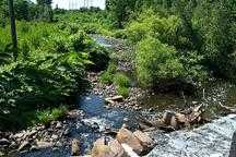
Indeed, a shoreline survey of the North
Nashua River within the Fitchburg City limits
conducted by the Fitchburg Stream Team in fall of 1999 and
repeated in 2000 noted "slimy, sludge, biofilm substrate
in various sections which need remediation."6
Although several problems were noted including evidence of
an old oil spill, storm drains, trash and some debris the
river was generally described as having a good buffer and
was "aesthetically pleasing" in its upper reaches.
In its lower reaches the Fitchburg Stream Team described many
aesthetically objectionable conditions and multiple problems
were identified including channelization, sewage odors, evidence
of cyanide spill (odor)7
, moderate turbidity (grayish tinge of the water column),
abandoned transformers, several dump sites, storm drains,
trash/debris, erosion, sedimentation, and discharge pipes.
The DWM's habitat assessment identified a sewer manhole structure
with signs of overflow (toilet paper). Finally, increasing
urbanization leads to diminished groundwater recharge and
to declining stream flow as well as stream channel shoaling,
widening and downcutting.
back to
top
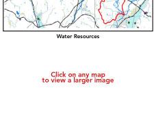
Major Water
Resource Issues: The North Nashua
River is classified as a Class B waterbody, and a warm water
fishery. Other than the river itself, the largest waterbodies
are Spectacle and White Ponds. There are two water withdrawal
permitees:
- Munksjo Paper Décor, Inc. is
permitted to withdraw 1.08 MGD from their water intake station
with actual withdrawals averaging somewhat higher in past
years;
- Simonds Cutting Tools is registered
to withdraw a total 0.26 MGD from their eight wells.
There are three wastewater treatment facilities
(WWTF) in this subbasin: Leominster WWTF and the Easterly8
and Westerly Fitchburg9
WWTFs. These account for the subbasin's three NPDES major
municipal effluent discharge permits. Two additional NPDES
minor industrial discharge permits are: Simonds Industries
in Fitchburg10
and River Terrace Healthcare in Lancaster.
On a historical note, it has been since
the WWTFs were built in the 1970's that the North Nashua River
has been designated as able to Class B status. Prior to this
the river was classified as "U" or unfit for any
designated uses. Indeed, it was considered one of the ten
worst rivers in the entire nation given regular releases of
untreated sewage and industrial wastes into the river and
its tributaries. The only living aquatic organisms were sludge
worms and the water was so full of paper industry effluents
that it was solid enough for small mammals to cross over.
It also regularly changed color, taking on the color of the
paper mill dyes that were released and was generally so offensive
as to render riverfront property worthless.
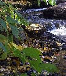
Things have dramatically improved and
recovered aquatic and riverine habitat sustains much life.
Still, according to the 1998 Nashua River Watershed Report
Card, the North Nashua River from the Whitman River intersection
to the Fitchburg Paper Plant is rated as partially-supportive
of biology and toxicity and non-supportive of swimming and
boating. From the Fitchburg Paper Plant to the Easterly Wastewater
Treatment Facility it is rated as non-supportive of aesthetics,
biology, toxicity, swimming and boating. From the Easterly
WWTF to the Leominster WWTF it is rated as partially-supportive
of biology and non-supportive of aesthetics, toxicity, swimming
and boating. From the Leominster WWTF to the Mainstem Nashua
River it is rated as partially-supportive of aesthetics, biology,
nutrients and boating and non-supportive of swimming. The
entire 19.5-mile length of the North Nashua River was assessed
as non-support for both recreational uses. Toxicological support
is most affected by chronic effluent from municipal point
sources, while swimming and boating support is most affected
by bacteria and other pathogens from Combined Sewer Overflows
(CSOs)11
and Dry Weather Overflows (DSOs).
According to the NRWA's 2000 Volunteer
Monitoring Water Quality Report, all of the sites in Fitchburg
exceed the state standard for fecal coliform. Both of the
sites on the North Nashua — at McDonald's parking lot
and Depot Street bridge in West Fitchburg — had many
samples in which fecal coliform colonies were too numerous
to count (TNTC). Fecal coliform is a major problem on the
North Nashua River in Fitchburg. It is possible that these
sites are effected by municipal wastewater discharge(s), combined
sewer overflows which dump untreated wastewater directly into
the rivers, and other urban runoff. If combined sever overflows
are the major contributing source of pathogens, ameliorating
the problem is likely to take a long time.12
In sum, aquatic life is impacted in the
urbanized reaches of the subbasin due to instream toxicity,
pathogens, and aesthetic degradation (sewage odor and turbidity
in the water column). Human contact in these areas should
be limited and/or cautious.
back to
top
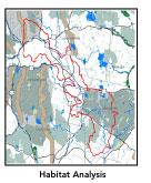
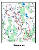
Recreation
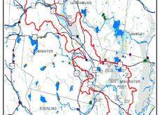
and Priority Habitat Areas: More
than 5 miles of the long-distance Mid-state Trail passes through
this subbasin; although it may be noted that there are no
trail easements thereon.
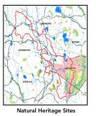
There is one state-designated Natural
Heritage and Endangered Species Project (MA NHESP) Priority
Habitat area centered on Spectacle Brook on the South Post
of Fort Devens. There are two MA NHESP Rare Wetlands priority
sites: one overlapping the Spectacle Brook area and another
centered on the North Nashua River downstream of Ponakin Brook
to the junction with the South Nashua River. There are three
core areas identified in the Nashua River Habitat Assessment
Report (MAS, 2000) which encompass parts of this subbasin:
- Squannacook Headwaters;
- Leominster/Lancaster Forests; and,
- South Post/Devens.
The three habitat protection focus areas
in this subbasin are:
- McGovern Brook;
- Ballard Hill; and,
- Devens/Oxbow.
The McGovern Brook focus area, including
White Pond and a stretch of the North Nashua River, is high
quality habitat in its own right, but is of utmost importance
as a buffer between downtown Leominster and the Oxbow focus
area (as is Ballard Hill). The combination of wetlands and
gravel pits could provide ideal habitat for turtles looking
for sandy deposits for their eggs. The north bank of the North
Nashua includes low-lying land that could develop as floodplain
forest, an uncommon natural community type in the watershed.
Priorities are to ensure that abandoned gravel pits are not
converted to another intensive use, and land on the south
bank of the North Nashua River. Devens/Oxbow is a large focus
area which, together with McGovern Brook and Ballard Hill
focus areas, creates a wildlife habitat anchor in this section
of the watershed. The clear protection priority in this focus
area recommended in the MAS 2000 Habitat Report is the continued
and long-term management of Devens South Post in ways that
are conducive to maintaining wildlife habitat.
back to
top
Resource Protection
Goals and Recommended Actions
GOAL: Protect wildlife
habitat and migration corridors in the subbasin.
- Land protection efforts to focus on Devens
South Post, McGovern Brook and Ballard Hill areas.
- Sponsor local events to raise public understanding
about native wildlife and the impacts of development patterns
on ecosystem and habitat integrity.
- Work with local conservation commissions
to gain their backing of natural resource and habitat inventories.
- Monitor the fishery and fisheries habitat
enhancement.
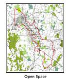
GOAL: Protect high-priority open space, vistas,
and community character in the subbasin.
- Encourage the use of MA Executive Order 418*
funding for Open Space and Resource Protection Plans for
each Massachusetts community in this subbasin.
- Conduct public education sessions to promote
local passage of Community Preservation Act*.
- Monitor progress of grants and projects related
to "Brownfields"13
cleanup and rehabilitation.
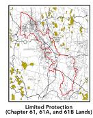
- Work toward ideal of at least 25-50% protected
open space in each municipality. Determine which Chapter
61, 61A and 61B properties to pursue Right of First Refusal*
options on if the opportunity arises.
- Work with municipal officials to develop
subdivision standards that require proponents to devote
at least 50% of land (not including already undevelopable
wet or steep land) for open space conservation and encourage
mixed-use development and cluster zoning by-right bylaws.
GOAL: Increase recreational opportunities
throughout the subbasin.
- Remedy potentially dangerous dam fragments
on North Nashua River at Leominster Italian-American Club
- Re-examine the feasibility of developing
a riparian greenway trail along the North Nashua River.
- Educate the public and municipal departments
(especially Public Works Depts) on efforts relating to invasive
species identification and removal.
GOAL: Improve water quality in the subbasin.
- If West Fitchburg WWTF continues to have
problems meeting their whole effluent CNOEC (chronic no
observed effect concentration) limit, the need for a toxicity
identification and reduction evaluation (TIE/TRE*)
should be determined.
- The East Fitchburg WWTF needs to be upgraded
in order to meet their biological oxygen demand (BOD), suspended
solids and total residual chlorine (TRC) permit limits.
Their new permit is currently being developed. All planning
in the city including possible upgrades to the two treatment
facilities (i.e., tie-in of municipal wastewater from the
West Fitchburg WWTF and CSO abatement and controls) needs
to be coordinated.
- Evaluate effectiveness of Leominster WWTF
dechlorination.
- Assist Fitchburg and Leominster with its
Clean Water Act-mandated MS-4 Phase II Stormwater requirements*.
These municipalities will be required to obtain permits
to reduce impacts to the receiving streams through the development
of Best Management Practices (BMPs), elimination of cross-connections
and significant public education. CSO controls and the development
of a long-range control plan will be required.
- Determine locations of combined sewer overflows
(CSOs) in Fitchburg and Leominster. Continue to track progress
of CSO abatement activities. Conduct additional dry and
wet weather fecal coliform bacteria monitoring in most impacted
segments of North Nashua River to identify potential sources
of pathogens and other contaminants.
- Because of the evidence of instream toxicity,
in order to identify sources of toxicity, bacteria and nutrient
impairments, an impact evaluation should be conducted throughout
this subbasin to include: biological monitoring (benthic
macroinvertebrate and fish), sediment quality characterization
(physio-chemical and toxicity testing), in-stream toxicity
testing, and water quality monitoring (i.e.: site specific
contaminants of concern). Conduct SMART14
monitoring.
- Continue to monitor nutrient concentrations
in most impacted segments of the North Nashua River and
evaluate the NPDES facilities compliance with their effluent
total phosphorous (TP*) limits. Reissue appropriate limits
for all WMA and NPDES permitees
- Reduce whole effluent and instream toxicity
in the North Nashua River.
- Reduce impervious cover to below 20% threshold.
- Closely monitor US Army Corps of Engineers
local flood protection project in Fitchburg's North Nashua
River to ensure environmental sensitivity if/when there
is DPW removal of shoals and riverbank vegetation. Support
and pursue 1135 River Restoration Grant through USACOE.
- Optimize water withdrawal practices to maintain
minimum streamflows, and to the extent possible, natural
flow regimes.
- Identify and rectify problems with factory
floor drains that may still discharge pollutants to waterways
(versus to tight tank or sewer system).
- Inventory, monitor and improve stormwater
drainage structures and implement Best Management Practices
(BMPs) to reduce the impacts of storm water runoff.
- Any plans to remove dams through the Fitchburg
portion of the Nashua River must account for the effects
of altered hydrology on other pollution abatement planning.
- Identify underground storage tanks (USTs)
and work to have them removed.
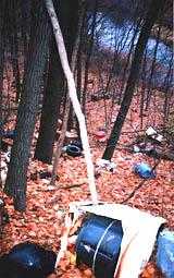
- Investigate illegal dump sites identified
by stream teams and public-at-large.
- Help develop and disseminate BMPs for small-scale,
hobby type agricultural operations.
GOAL: Reduce potential negative effects of
some development in this subbasin.
- Help local volunteer board members
responsible for development and land-use rulemaking and
enforcement get technical assistance and information regarding
techniques to control/guide land use and development balanced
with adequate resource protection (e.g., Citizens Planner
Training Collaborative15
workshop offerings).
- Increase or establish staff hours of municipal
conservation agents to more effectively monitor construction
sites runoff and assist with the preparation of bylaws such
as erosion-sedimentation controls.
back
to top
|