|
Geographic
Overview and Ecosystem Characteristics:
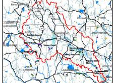
Located in "fuzzy" zone encompassing parts of both the
Upper Worcester Plateau and the Southern New England Coastal Plains
and Hills ecoregions1
of north central Massachusetts and southern New Hampshire, this
area drains southeasterly into the main stem of the Nashua River
near Ayer, Massachusetts. The Massachusetts communities of Groton,
Shirley, Ashby, Pepperell, and Townsend lie wholly or partially
within the Squannacook Watershed, as do the New Hampshire communities
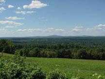
of Greenville, New Ipswich, and Mason. The topography ranges from
steep "upland plateau" in the north and western sections
to more gently rolling, hilly terrain to generally flat "coastal
plain" lowland river valleys.
Designated an Outstanding Resource Waters (ORW)*,
the Squannacook River is a high-value riverine ecosystem with high
aesthetic quality and great wildlife habitat. Further, the subbasin
has the distinction of being the focus of the Squannacook-Nissitissit
Rivers Sanctuary Act (MGL 132A:17) passed in 1975 and intended to
protect the ORWs of these two river basins from degradation by new
discharges of pollution. The basin is considered to be a net exporter
of surface water.
Streamflow, as in most of New England, has significant
seasonal changes. Its headwaters drain an area that is some of the
most forested (79%), least developed (10% residential) in the watershed.
This results in a cold, clean main stem river that is frequently
cited as prime habitat for listed rare species and native brook
trout in the upper reaches.
back to top
Land Ownership and
Land Use2
Patterns: Land-use patterns vary from
low-density residential in the uplands to more concentrated settlement
and strip developments in the valleys, including gravel extraction,
commercial operations and industry. Much of the subbasin is undeveloped,
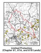
containing large areas of privately owned open spaces and a significant
percentage of permanently protected land (Willard Brook State Forest,
Pearl Hill State Park, Townsend State Forest, and Squannacook Wildlife
Management Area as well as municipal and private non-profit conservation
land). A low percentage (less than 8%)3
of total impervious surfaces — namely, paved areas such as
streets, driveways, and parking lots — for this whole subbasin
indicates that issues of compromised stormwater and other non-point
sources4
of contaminants (for example: pesticides, fertilizers, oils, asphalt,
pet wastes, salt, sediment, litter and other debris) is not an immediate
pressing concern. As the Squannacook watershed becomes increasingly
developed, there will be more threat of water quality deterioration
from risks associated with urbanization, including thermal pollution,
over-fertilization of lawns, improper handling of hazardous wastes,
septic system leachate, street runoff, and the like.
back to top
Major Water Resource
Issues: This
sub-basin as a whole contains important headwaters and high quality
groundwater that are under intense development pressure which poses
a threat to the future quantity and quality of the resource. As
for other issues and
areas warranting attention, all three
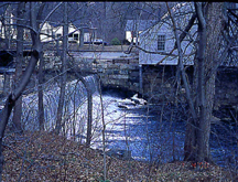
major impoundments along the Squannacook — Hollingsworth &
Vose (H& V), Leatherboard, and Harbor Ponds — are excessively
vegetated. Also, elevated phosphate levels in each have fostered
cultural eutrophication*
negatively impacting recreational opportunities (boating, fishing
and swimming). According to the 1998 Nashua River Watershed Report
Card, the Squannacook River between Harbor Pond and Hollingsworth
& Vose is rated as on alert for chemistry and swimming and partially
supportive of biology5
due to elevated temperature readings above those protective for
a cold water fishery. Downstream of Harbor Pond there are increasing
water quality problems due to high levels of fecal coliform, low
dissolved oxygen, erosion leading to sedimentation, increasing siltation
and noxious aquatic and invasive weeds in Harbor Pond itself. Bixby
Reservoir and Coon Tree Pond are both in an eutrophic state and
contain noxious plants.
back to top
Recreation and
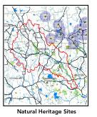
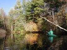
Priority Habitat Areas: Important habitat
areas in this subbasin include: Wrights Ponds, Willard Brook State
Forest, the Throne, and Townsend State Forest, which supports headwater
streams of the Squannacook River. Trapfalls, Locke, and Pearl Hill
Brooks each support Native Eastern Brook Trout as well as stocked
trout. Flat Pond Brook in Townsend which had native Eastern Brook
Trout until very recently, has been noted by fisheries experts to
be filling in with sediment. Bayberry Hill, Bixby, Mason, Pumpkin,
Walker, and Witch Brooks in Townsend are all cold-water fisheries
and, with the exception of Bayberry Hill Brook, are also stocked
with trout. In particular, conservation of riverfront lands is highly
important, as a riverine "greenway" acts as a vegetated
buffer to protect water quality and wildlife habitat, to prevent
flood damage, and to provide outstanding recreation opportunities.
back to top
Resource Protection
Goals and Recommended Actions
GOAL: Protect wildlife habitat
and migration corridors in the subbasin.
- Expand the Squannacook River Wildlife Management
Area along Witch Brook and Ash Swamp and the Willard Brook and
Townsend State Forests.
- Sponsor local events to raise public understanding
about native wildlife and the impacts of development patterns
on habitat and ecosystem integrity.
- Work with local conservation commissions to gain
their backing of natural resource/ habitat inventories.
GOAL: Protect high-priority open space, vistas,
and community character in the subbasin.
- Encourage the use of MA Executive Order 418*
funds to complete municipal Open Space and Recreation Plan and
other more site specific resource protection plans for each Massachusetts
community in the Squannacook subbasin.
- Conduct public education sessions to promote local
passage of Community Preservation Act*.
- Work toward ideal of at least 25-33% protected
open space in each municipality.
- Work with municipal officials to develop subdivision
standards that require proponents to devote at least 50% of land
(not including already undevelopable wet or steep land) for open
space conservation and encourage mixed-use development and cluster
zoning by-right bylaws.
- Develop strategy for protecting Fessender Hill,
as well as the views from Barker Hill and West Meadow Roads.
- Support efforts of the Squannassit Regional Reserve
Initiative*
(facilitated by the NRWA) and the Squannassit ACEC nomination
which encompasses much of this subbasin.
- Encourage municipalities to adopt and enforce "Scenic
River Protection" type bylaws*
(similar to Townsend's Squannacook River Protection bylaw).
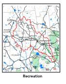
GOAL: Increase recreational opportunities throughout
the subbasin.
- Re-examine the feasibility of developing a multi-purpose
trail along the abandoned B&M railway parallel to the Squannacook
River from Ayer through Townsend.
- Improve canoeing, fishing, and swimming opportunities
by removing weeds from water bodies.
- Educate the public and municipal departments (especially
Public Works Depts.) on efforts relating to invasive species identification
and removal.
GOAL: Improve water quality in the subbasin.
- Support source water protection efforts of
local communities, land trusts, and water suppliers.
- Implement Total Maximum Daily Load (TMDL) Action
Plan for Harbor Pond when completed.
- Fund and install maintainable silt/sediment trapping
forebay in Squannacook River behind existing dams prior to its
reaching Harbor Pond.
- Extend the Squannacook-Nissitissit Sanctuary Act
into the New Hampshire portion of the watershed.
- Identify the major sources of phosphate inputs
to the river and work with communities to address the problem.
- Assist the Town of Groton in implementing EPA's
Phase II stormwater requirements. This municipality will be required
to obtain permits to reduce impacts to the receiving streams through
the development of BMPs, elimination of cross-connections and
significant public education. CSO controls and the development
of a long-range control plan will be required.
- Inventory, monitor and improve stormwater drainage
structures.
- Identify the degree of threat from potential faulty/
illicitly discharging septic systems, which may result in bacterial
and nutrient contamination of nearby streams and groundwater.
- Identify underground storage tanks (USTs) and work
with communities to have them removed.
GOAL: Reduce negative effects of development in
this subbasin.
- Help local volunteer board members responsible
for development and land-use rulemaking and enforcement get technical
assistance and information regarding techniques to control/guide
land use and development balanced with adequate resource protection
(e.g., Citizens Planner Training Collaborative6 workshop offerings).
- Monitor increased imperviousness, both direct and
indirect riparian zone alterations, and uncontrolled runoff from
construction sites to prevent increased stream temperature and
sedimentation through macroinvertebrate sampling performed by
volunteer stream team monitors.
- Increase or establish staff hours of municipal
conservation agents to more effectively monitor construction sites
runoff and assist with the preparation of bylaws such as erosion-sedimentation
controls.
back to top
.
|