|
Geographic
Overview and Ecosystem Characteristics:
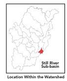
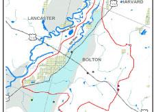
This subbasin1
predominantly lies in the community of Bolton,
with extensions into Lancaster and Harvard. Located in the Southern
New England Coastal Plains and Hills ecoregion of central Massachusetts,
the Still River flows into the mainstem Nashua River at the intersection
of Harvard and Lancaster just north of the Bolton town line. Routes
117 and 110 travel through this subbasin.
The Coastal Plains and Hills ecoregion is an
area with generally similar soils, vegetation, shape of the land,
and especially, cool climate and bedrock geology (glacial tills
and outwash deposits). Streamflow, as in most of New England, has
significant seasonal changes2.
The eastern boundary of this subbasin forms a north-south running
ridgeline.
A portion of the Central Nashua River Valley Area of Critical Environmental
Concern (ACEC) — currently the only ACEC in the Nashua River
watershed — falls along the entire western boundary of this
subbasin in Bolton and Lancaster.
back
to top
Land Ownership and
Land Use3
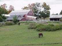
Patterns: The land-use pattern is 49%
forest (hardwood mixed with softwood) or wetland. Low-density residential
settlement as well as concentrated settlements and strip development
located near town centers and along major roads account for 17%
residential use. 22% of total land area is agriculture and/or open
space. Additionally, there are a number of gravel pits. Nashoba
Regional High School, International Golf Course and the Lancaster
Prison are three large institutions in this subbasin.
Indeed, a low percentage (8%) of total impervious
surfaces4
— namely, paved areas such as streets, driveways, and parking
lots — for this subbasin indicates that issues of compromisestormwater
and other non-point sources of contaminants5
(for example: pesticides, fertilizers, oils, asphalt, pet wastes,
salt, sediment, human litter and other debris) are not an immediate
pressing concern.
back to top
Major Water Resource
Issues: A large high-yield aquifer running
in a north-south direction underlies much of this subbasin. The
Still River is classified as a Class B*
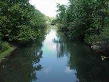
waterbody. Major waterbodies in this subbasin are the Still River
and its associated small feeder streams, marshes and small oxbow
lakes. There are neither any NPDES* permits nor registered water
withdrawals permits in the subbasin. In years past, the NRWA conducted
water quality monitoring sampling (fecal coliform bacteria, pH or
DO samples) in the Still River. NRWA's data indicated low dissolved
oxygen levels as is typical for the entire Nashua River system.
Polluted runoff and sedimentation is an increasingly serious issue
in rapidly developing communities
back to top
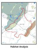
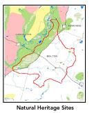
Recreation and
Priority Habitat Areas: The largest permanently
protected block in this subbasin is the Bolton Flats Wildlife Management
Area (WMA) through which the subbasin boundary runs. The nearly
1,000 acre largely trail-less Bolton Flats WMA — consisting
of level agricultural fields interspersed with hedgerows, floodplain
hardwoods and wetlands shrubs — is also a designated Watchable
Wildlife Viewing Area6.
The area is of special interest for the great variety of birds it
supports, especially during migratory periods.
The entire Bolton Flats WMA is also this subbasin's
one state-designated Natural Heritage and Endangered Species Project
(MA NHESP) Priority Habitat Area as well as its only MA NHESP Rare
Wetlands Wildlife site, in which many listed species and uncommon
plant communities have been identified. One habitat protection focus
area identified in the Nashua River Habitat Assessment Report (MAS,
2000), Devens/Oxbow/Bolton Flats, is considered a wildlife habitat
anchor, which encompasses the northwest quadrant of this subbasin
as does a so-called "Devens South Post" core area. Additional
conservation lands include Vaughn Hills municipal Conservation Area.
Recommended habitat conservation priorities should focus on unprotected
land adjacent to Still River.
back to top
Resource Protection
Goals and Recommended Actions
GOAL: Protect wildlife habitat
and migration corridors in the subbasin.
- Land protection efforts to focus undeveloped lands
in Still River floodplain (notably along Route 110).
- Sponsor local events to raise public understanding
about native wildlife and the impacts of development patterns
on ecosystem and habitat integrity.
- Work with local conservation commissions to gain
their backing of natural resource and habitat inventories.
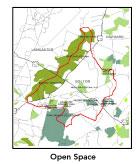
GOAL: Protect high-priority open space, vistas,
and community character in the subbasin.
- Protect agricultural views from Route 110 adjacent
to river.
- Encourage the use of MA Executive Order 418*
funding for Open Space and Resource Protection Plans for each
Massachusetts community in this subbasin.
- Conduct public education sessions to promote local
passage of Community Preservation Act*.
- Work toward ideal of at least 25-50% protected
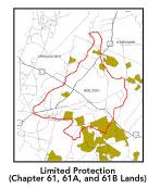
open space in each municipality. Determine which Chapter 61, 61A
and 61B properties to pursue Right of First Refusal*
options on if the opportunity arises.
- Work with municipal officials to develop subdivision
standards that require proponents to devote at least 50% of land
(not including already undevelopable wet or steep land) for open
space conservation and encourage mixed-use development and cluster
zoning by-right bylaws.
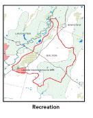
GOAL: Increase recreational opportunities throughout
the subbasin.
- Educate the public and municipal departments (especially
Public Works Depts) on efforts relating to invasive species*
identification and removal.
GOAL: Improve water quality in the subbasin.
- Identify any WMA withdrawals in the Still River
subbasin.
- Identify underground storage tanks (USTs) and work
to have them removed.
GOAL: Reduce potential negative effects of some
development in this subbasin.
- Help local volunteer board members responsible
for development and land-use rulemaking and enforcement get technical
assistance and information regarding techniques to control/guide
land use and development balanced with adequate resource protection
(e.g., Citizens Planner Training Collaborative7
workshop offerings).
- Increase or establish staff hours for municipal
conservation agents to more effectively monitor construction sites
runoff and assist with the preparation of bylaws such as erosion-sedimentation
controls.
back
to top
|