|
Geographic
Overview and Ecosystem Characteristics:
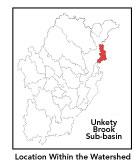
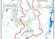
This subbasin1
predominantly lies in the communities of Dunstable and Groton, with
small extension into Pepperell. Located in the Southern New England
Coastal Plains and Hills ecoregion2
of central Massachusetts, Unkety Brook flows into the Nashua River
downstream of the Pepperell Wastewater Treatment Facility just a
mile south of the New Hampshire line. Route 113 passes through this
subbasin. Streamflow, as in most of New England, has significant
seasonal changes3.
The southern half of the eastern boundary of this subbasin is defined
by a northeast-southwest running ridgeline.
back to top
Land Ownership and
Land Use4
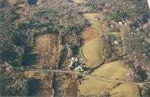
Patterns: The land-use pattern is 50%
forest (hardwood mixed with softwood) or wetland. Low-density residential
settlement as well as concentrated settlements and strip development
located near town centers and along major roads account for 16%
residential use. A relatively high percentage, 16%, of total land
area is agriculture and/or open space. Indeed, a very low percentage
(6.6%, the lowest of all 22 Nashua River subbasins) of total impervious
surfaces5
— namely, paved areas such as streets, driveways, and parking
lots — for this subbasin indicates that issues of compromised
stormwater and other non-point sources of contaminants6
(for example: pesticides, fertilizers, oils, asphalt, pet wastes,
salt, sediment, litter and other debris) are not an immediate pressing
concern.
back to top
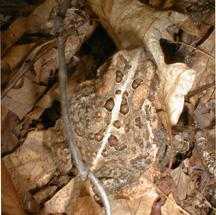
Major Water Resource
Issues: Unkety Brook is classified as
a Class B*
waterbody and is a warmwater fishery. It headwaters are in Groton
to the east of Chicopee Row north of the Chestnut Hills with another
unnamed tributary emerging at the western base of the Horse Hill
ridge. It flows through significant wetlands where it is exposed
to direct sunlight, and lacking dramatic relief in its bed is therefore
slow moving. Some new neighborhood development on adjacent upland
may influence the water quality in the Brook. Polluted runoff and
sedimentation is an increasingly serious issue in rapidly developing
communities.
A shoreline survey was conducted by the Unkety
Brook Stream Team in the spring of 1997. In short, its findings
were that Unkety Brook: "is a wonderful resource for the Town
of Dunstable and provides excellent riparian and aquatic habitat.
The Brook is also threatened in many places from non-point source
pollution, new construction and damaging agricultural practices."
At the time, manure piles as close as 50 feet from the Brook at
a farm, was considered noteworthy as were sections on the brook
containing the invasive plant*
purple loosestrife. One other major problem was at a farm where
animals had open access to the brook causing sedimentation and damaging
riparian vegetation. Nashua River Watershed Association's Volunteer
Water Quality Monitoring Program has noted that Unkety Brook shows
perennially low dissolved oxygen (DO) levels probably due to slow
flow and increased oxygen demand in wetland areas. In some areas
the DO levels are below that necessary to support even warm water
fishes.
A medium-yield aquifer underlies a portion of
this subbasin underlying the southern half of Unkety Brook. There
are no major waterbodies, no major water withdrawals, nor any NPDES*
permits in this subbasin.
back to top
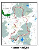
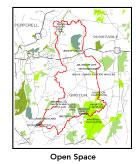
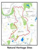
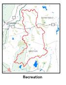
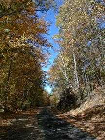
Recreation and
Priority Habitat Areas: The most significant
permanently protected areas in this subbasin are: the New England
Forestry Foundation's (NEFF) Wharton Plantation, the Larter Family
Agricultural Protection Restriction in Dunstable, and a string of
Groton Conservation Commission holdings (Ripley Forest and Floyd/Groton
Hills Conservation Areas). The Department of Environmental Protection's
(DEM) 1983 Scenic Inventory Protect identified a small section in
the southwest portion of this subbasin as contributing "distinctive"
scenic character to the entire region. Less than a mile of the 12
mile-long Ayer to Dunstable Rail Trail, owned and managed by the
Department of Environmental Protection, is located in the northernmost
portion of this subbasin. This Rail Trail is just being constructed
as a combined bicycling, walking, and bridle trail.
Nearly all of this subbasin is considered to
be a Natural Heritage and Endangered Species Project (MA NHESP)
BioMap core area7
. There are three state-designated MA NHESP Rare Wetlands Wildlife
Habitat areas in this subbasin, which are designated Priority Habitat
areas as well. These are: along Unkety Brook in southwestern Dunstable;
and two nearly adjacent sights to the north and east of Chestnut
Hills and south of Baddacook Hill in Groton. A fourth MA NHESP Priority
Habitat area is located along the power line straddling the Groton-Dunstable
border. This entire subbasin falls within the proposed Petapawag
Area of Critical Environmental Concern (ACEC)8
nomination.
Two habitat protection focus area identified
in the Nashua River Habitat Assessment Report (MAS, 2000)
are:
- Horse Hill-Baddacook Hill: an area on the
watershed boundary in Groton and Dunstable covering most of the
southeastern portion of this subbasin which includes NEFF's Wharton
Plantation as well as the Town of Groton Conservation Commission
and Water Department, and the Groton Conservation Trust.
- Hound Meadow Hill-Hawk Swamp: the lightly
developed northwestern corner of Dunstable important for its role
as buffer for the Unkety Brook and associated wetlands and their
adjacent wooded uplands. Hawk Swamp, which is bisect by Route
113, is a spruce-fir boreal swamp, and an example of a natural
community type near the southern end of its range. Unkety Brook
has been identified as exceptional habitat for aquatic wildlife.
Priorities include the low land adjacent to Unkety Brook. Another
priority for protection of a riparian corridor habitat is east
of River Street.
back to top
Resource Protection
Goals and Recommended Actions
GOAL: Protect wildlife habitat
and migration corridors in the subbasin.
- Create a riverside greenway and insure habitat
preservation, especially for state-listed threatened species such
as the wood turtle.
- Sponsor local events to raise public understanding
about native wildlife and the impacts of development patterns
on ecosystem and habitat integrity.
- Work with local conservation commissions to gain
their backing of natural resource and habitat inventories.
GOAL: Protect high-priority open space, vistas,
and community character in the subbasin.
- Encourage the use of MA Executive Order 418*
funding for Open Space and Resource Protection Plans for each
Massachusetts community in this subbasin.
- Conduct public education sessions to promote local
passage of Community Preservation Act*.
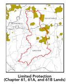
- Work toward ideal of at least 25-50% protected
open space in each municipality. Determine which Chapter 61, 61A
and 61B properties to pursue Right of First Refusal*
options on if the opportunity arises.
- Work with municipal officials to develop subdivision
standards that require proponents to devote at least 50% of land
(not including already undevelopable wet or steep land) for open
space conservation and encourage mixed-use development and cluster
zoning by-right bylaws.
GOAL: Increase recreational opportunities throughout
the subbasin.
- Educate the public and municipal departments (especially
DPWs) on efforts relating to invasive species identification and
removal.
- Support efforts of the Squannassit Regional Reserve
Initiative*
(facilitated by the NRWA) and the Petapawag nomination which encompasses
much of this subbasin.
GOAL: Improve water quality in the subbasin.
- Help develop and disseminate Best Management Practices
(BMPs)*
for small-scale, hobby type agricultural operations.
- Identify any WMA withdrawals in this subbasin.
- Identify underground storage tanks (USTs) and work
to have them removed.
GOAL: Reduce potential negative effects of some
development in this subbasin.
- Monitor development along the banks of Unkety Brook
to ensure building practices are sensitive to riparian habitat
and water quality considerations.
- Help local volunteer board members responsible
for development and land-use rulemaking and enforcement get technical
assistance and information regarding techniques to control/guide
land use and development balanced with adequate resource protection
(e.g., Citizens Planner Training Collaborative9
workshop offerings).
- Increase or establish staff hours for municipal
conservation agents to more effectively monitor construction sites
runoff and assist with the preparation of bylaws such as erosion-sedimentation
controls.
back to top
.
|