|
Geographic
Overview and Ecosystem Characteristics:
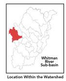
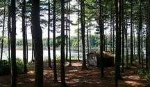
Most of this subbasin1
lies in the communities of Ashburnham and Westminster with parts
extending into Gardner and Fitchburg. Predominately located in the
Upper Worcester Plateau ecoregion2
of central Massachusetts, this area drains southeasterly into the
North Nashua River in Fitchburg just below Snow Mills Pond. Streamflow,
as in most of New England, has significant seasonal changes3.
Topography is generally hilly, encompassing numerous flatter wetlands,
broad valleys, and floodplains.
back to top
Land Ownership and
Land Use4
Patterns: The land-use pattern is 72%
forest (hardwood mixed with softwood) or wetland plus 10% residential
(low-density settlement as well as concentrated settlements and
strip development located near town centers and along major roads).
Less significant are agriculture (notably "hobby farms"
and backyard horse paddocks), gravel extraction, commercial operations,
industry and other developed land uses. This mix gives rise to a
number of existing and potential conflicts with potential pollutants
including sediment, nutrients, and oil/gas.
A low percentage (less than 10%) of total impervious
surfaces5
— namely, paved areas such as streets, driveways, and parking
lots — for this whole subbasin indicates that issues of compromised
stormwater and other non-point sources of contaminants (i.e.: pesticides,
oils, fertilizers, asphalt, pet wastes, salt, sediment, human litter
and other debris) are not an immediate pressing issue.
back to
top
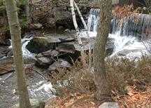
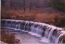
Major Water Resource
Issues: The amount of permanently protected
undeveloped open space in the subbasin has meant that the water
quality in the subbasin remains high. Regarding water withdrawals:
one water withdrawal permit is for the Westminster Golf Course which
draws its water from Burnt Millpond; another is for Intercontinental
Recycling Corporation which averages approximately 1.25 million
gallons per day (MGD) of surface water withdrawal from Snows Millpond.
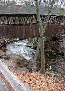
This subbasin features a network of unnamed
streams and swamps with the exception of the large Tophet Swamp
just to the northwest of Westminster center. Notable waterbodies
in the subbasin include: Lake Wampanoag, Whitmanville Reservoir,
Crocker Pond, Muddy Pond, Burnt Millpond, Partridge Pond, and Round
Meadow. The last two are characterized as eutrophic with noxious
plants*;
Patridge Pond is also somewhat turbid.
According to the NRWA's 2000 Volunteer Monitoring
Water Quality Report, the Whitman River — sampled near the
Vocational-Technical school behind the sewage pumping station —
was relatively free of coliform bacteria. The river is well-oxygenated.
This site fell below the state standard for pH, but low pH is likely
the normal background condition. All other parameters measured indicate
clean water.
As for specific areas of concern, according
to the 1998 Nashua River Watershed Report Card, the Whitman River
is rated as on alert for aquatic biology. When the state Division
of Water Management last sampled in summer of 1998, vast amounts
of an algae were present, which is indicative of the presence of
elevated levels of nutrients. Likewise, the rocks in the streams
were covered with algae typically associated with abundant nutrients.
Given the abundant algal community and other indications that the
surface waters may be responding to a stressor — possibly nutrients
— the River is considered to be on "Alert Status".
Finally, there is considerable suspended sediments in the River,
possibly from road sanding operations run-off.
back to
top
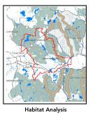
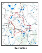
Recreation and
Priority Habitat Areas: More than 5 miles
of the long-distance Mid-state Trail pass through the Town of Westminster
Muddy Pond Conservation Area, Westminster State Forest and private
holdings in this subbasin; although it may be noted that there are
no trail easements thereon. There is great potential for a Rail-to-Trail
project along the old B & M line as it runs north through Westminster
and Ashburnham to join the existing Rail-to-Trail line in Winchendon
and on into Rindge, New Hampshire.
High Ridge Wildlife Management Area (WMA) is
a more than 2,000 acre habitat for wildlife designated as a Watchable
Wildlife Viewing Area. This WMA includes extensive open meadows
managed for hay their associated bird communities and which therefore
have or have the potential for threatened grassland nesting bird
habitat. Wetlands within this area provide habitat for state-endangered
American bitterns, a strong indicator of low human disturbance.
MassWildlife staff report moose and bear activity in the area which
is consistent with the presence of open lands providing undisturbed
habitat for large mammals ranging south from the Mt. Watatic area.
Protection of the wetlands east and west of Overlook Road at the
southern end of this focus area, and the lands west of Murray Road
at the northern end are the conservation priorities.
Massachusetts Audubon Society's (MAS) Lake Wampanoag
Sanctuary consists of 360 plus acres of woodlands and wetland habitat,
notably a "spruce/ moose" habitat rarely found in Massachusetts.
Lake Wampanoag itself is one of the largest contiguous open space
and relatively undeveloped waterbodies in the watershed. The entire
lake is identified as a Priority Habitat by the MA Natural Heritage
and Endangered Species Program (NHESP). It is important for its
size, its large amount of interior, and its location on the western
edge of the watershed. According to the Nashua River Habitat
Assessment Report 2000 (MAS), it should be considered another
cornerstone of a reserve design for the Nashua River Watershed.
Important targets for habitat protection include all of the Priority
Habitat areas, especially undeveloped shoreline on Lake Wampanoag,
and parcels along the Old County Road which could possibly allow
access for development in the long term. Similarly, The NRWA 2020
Plan recommends acquiring conservation land along Whitman River
and Lake Wampanoag.
In addition to Lake Wampanoag, there are two
MA NHESP Priority Habitat sites in the High Ridge WMA area. There
are four habitat areas identified in the 2000 MAS Habitat Report,
which are:
- High Ridge (wholly within this subbasin);
- Lake Wampanoag;
- Muddy Pond; and,
- Parker Hill: # 2, 3 and 4 are approximately
50% within this subbasin.
This past summer of 2001, Muddy Pond was the
location of a more in-depth ecological inventory: the results of
which are still in draft. The unprotected sections of Muddy Pond
— one of very few wholly undeveloped waterbodies in the watershed
— is another recommended conservation priority.
back to top
Resource Protection
Goals and Recommended Actions
GOAL: Protect wildlife habitat
and migration corridors in the subbasin.
- High Ridge WMA includes extensive open meadows
managed for hay. Manage portions of the meadows expressly for
success of grassland nesters by delaying the first cut until after
August 1st.
- Land protection efforts to focus on undeveloped
shoreline on Lake Wampanoag and parcels along the Old County Road
in Ashburnham.
- Sponsor local events to raise public understanding
about native wildlife and the impacts of development patterns
on ecosystem and habitat integrity.
- Work with local conservation commissions to gain
their backing of natural resource and habitat inventories.
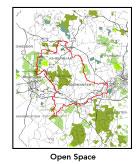
GOAL: Protect high-priority open space, vistas,
and community character in the subbasin.
- Encourage the use of MA Executive Order 418*
funding for Open Space and Resource Protection Plans for each
Massachusetts community in the Nissitissit subbasin.
- Conduct public education sessions to promote local
passage of Community Preservation Act*.
- Work toward ideal of at least 25-50% protected
open space in each municipality.
- Work with municipal officials to develop subdivision
standards that require proponents to devote at least 50% of land
(not including already undevelopable wet or steep land) for open
space conservation and encourage mixed-use development and cluster
zoning by-right bylaws.
- Encourage municipalities to adopt and enforce "Scenic
River Protection" type bylaws.
GOAL: Increase recreational opportunities throughout
the subbasin.
- Work toward securing trail easements on
sections of the Mid-state Trail.
- Improve canoeing, fishing, and swimming opportunities
by removing weeds from water bodies.
- Educate the public and municipal departments (especially
Public Works Depts.) on efforts relating to invasive species*
identification and removal.
GOAL: Improve water quality in the subbasin.
- Because of the indications that the river may be
responding to a stressor, possibly nutrients, additional monitoring
should be conducted. These investigations should include biological
(benthic macroinvertebrate), and physio-chemical (nutrients, DO,
pH) monitoring.
- Identify the major sources of phosphate inputs
to the river and work with communities to address the problem.
- Identify WMA withdrawals in the Whitman River subwatershed.
Evaluate compliance with registration and/or permit limits. Determine
potential impacts of withdrawals on streamflow/habitat.
- Assist Fitchburg, Gardner and Westminster with
their Clean Water Act-mandated MS-4 Phase II Stormwater requirements*.
These municipalities will be required to obtain permits to reduce
impacts to the receiving streams through the development of Best
Management Practices (BMPs)*,
elimination of cross-connections and significant public education.
CSO controls and the development of a long-range control plan
will be required.
- Help develop and disseminate BMPs for small-scale,
hobby type agricultural operations.
- Identify the degree of threat from potential faulty/
illicitly discharging septic systems, which may result in bacterial
and nutrient contamination of nearby streams and groundwater.
- Inventory, monitor and improve stormwater drainage
structures.
- Identify underground storage tanks (USTs) and work
to have them removed.
GOAL: Reduce negative effects of development in
this subbasin.
- Review the turf maintenance practices of area golf
courses near Burnt Millpond to determine potential non-point source
pollution from fertilizer use.
- Help local volunteer board members responsible
for development and land-use rulemaking and enforcement get technical
assistance and information regarding techniques to control/guide
land use and development balanced with adequate resource protection
(e.g., Citizens Planner Training Collaborative6
workshop offerings).
- Monitor increased imperviousness, both direct and
indirect riparian zone alterations, and uncontrolled runoff from
construction sites to prevent increased stream temperature and
sedimentation through macroinvertebrate sampling performed by
volunteer stream team monitors.
- Increase or establish staff hours of municipal
conservation agents to more effectively monitor construction sites
runoff and assist with the preparation of bylaws such as erosion-sedimentation
controls.
back
to top
.
|