|
Geographic
Overview and Ecosystem Characteristics:
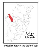
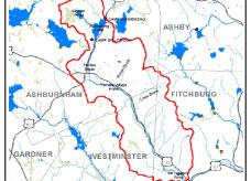
Most of this subbasin1
lies in the communities of Ashburnham, Westminster and Fitchburg
with a very small part extending into Ashby. Located in the
Upper Worcester Plateau ecoregion of central Massachusetts,
this area drains into the North Nashua River at Mill Number
3 downstream of the West Fitchburg Wastewater Treatment Plant
and upstream of downtown Fitchburg. Route 12 travels through
the center of this subbasin and Route 101 passes through a
portion as well.
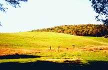
The Worcester Plateau (or Monadnock Highland)
ecoregion is an area with cool climate and bedrock geology
(glacial tills and outwash deposits) and generally similar
soils, vegetation, and shape of the land. Streamflow, as in
most of New England, has significant seasonal changes2.
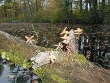
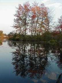
Browns Brook and Laws Brook are feeder streams to Phillips
Brook. Lake Winnekeag is the headwaters of Phillips Brook
and is in turn feed, in part, by Lincoln Pond. There are prominent
north-south ridgelines along both the eastern and western
boundaries of this subbasin. Topography is generally hilly
(notably Mount Hunger and Russell, Jewell, Brown, Buck, Alpine
Hills) encompassing numerous flatter wetlands and floodplains.
back
to top
Land Ownership
and Land Use3
Patterns: The land-use pattern
is nearly 75% forest (hardwood mixed with softwood) or wetland.
Low-density residential settlement as well as concentrated
settlements and strip development located near town centers
and along major roads account for a total of 9% residential.
10% of total land area is agriculture (notably diary and hay).
Gravel extraction, commercial operations, industry and other
developed land uses are less significant.
A very low percentage (7%) of total impervious
surfaces4
— namely, paved areas such as streets, driveways, and
parking lots — for this subbasin indicates that issues
of compromised stormwater and other non-point sources of contaminants
(for example: pesticides, fertilizers, oils, asphalt, pet
wastes, salt, sediment, litter and other debris) is not a
pressing concern. Indeed, a shoreline survey of the brook
from Lake Winnekeag Dam to Jewell Hill Rd was conducted by
the Phillips Brook Stream Team in summer of 1999. Their shoreline
survey indicated that the brook was in good condition overall.
Some threats to water quality, however, were identified including
beaver activity, increasing development of "marginal"
lots, storm drains (near Rt. 12/Main St. bridge), uncovered
DPW sand and salt storage pile, lawn waste disposal practices,
and road run-off/ erosion at bridge crossings such as where
Route 12 and Route 101 intersect the brook.
back to
top
Major Water
Resource Issues: Phillips Brook
is classified as a well-oxygenated, Class B waterbody, and
a warm water fishery. There are no wastewater treatment plants
in this subbasin. There are two NPDES minor discharge permits,
both in Ashburnham: one site permitted for industrial effluent
is Cushing Academy, and the other is Flo Chemical Corporation.
According to the NRWA's 2000 Volunteer
Monitoring Water Quality Report, many samples at the mouth
of Phillips Brook — upstream of the confluence with the
North Nashua River at Route 12 — had fecal coliform colonies
too numerous to count (TNTC). It is possible that these sites
are affected by Combined Sewer Overflows (CSOs) which, at
times, dump untreated wastewater directly into the rivers.
Two sites in Phillips Brook in Ashburnham — at the former
swim pond and at Lake Winnekeag's outfall — were relatively
free of coliform bacteria. These two sites fell below the
state standard for pH. Low pH at these sites is likely the
normal background condition, though a sampling of lake water
from Winnekeag may be helpful for comparison. All other parameters
measured indicate clean water.
Fecal coliform is a major problem on Phillips
Brook in Fitchburg. If Combined Sewer Overflows are the major
contributing source, ameliorating the problem is likely to
take a long time. Human contact in these areas should be limited
and/or cautious. In the past there had been unfenced cattle
access in to Phillips Brook, but this situation is no longer
present. In the summer of 2000, the NRWA conducted benthic
macroinvertebrate biological monitoring at three sites along
Phillips Brook the results of which are being tabulated.
back to
top
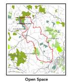
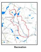
Recreation
and Priority Habitat Areas: The
DEM recently purchased land surrounding the wholly undeveloped
Lincoln Pond's eastern edge where an unbuilt residential development
was abandoned some years ago. This is an important acquisition
as it is a fine example of a Spruce-Tamarack Bog and as it
is to be added to Ashburnham State Forest serves as a further
buffer of protection for a very large area centered around
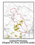
Little Watatic Mountain. The only other significant permanently
protected parcel in this subbasin is Town of Westminster's
Muddy Pond Conservation Area and the adjacent Westminster
State Forest in addition to a few Agricultural Protection
Restriction (APR) farms. There are a number of Chapter 61A-enrolled
properties in the subbasin as well including a large farm
with frontage on Phillips Brook, which is presently for sale.
Moran Playground and McTaggarts Pond are
other local recreation destinations, which are prominent in
being very close to densely populated Fitchburg neighborhoods.
The impoundment of Phillips Brook creating Bresnahan Pool,
which is the only public beach facility in Ashburnham, was
closed several years ago due to irreparable damage. More than
5 miles of the long-distance Mid-state Trail passes through
this subbasin; although it may be noted that there are no
trail easements thereon.
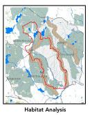
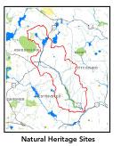
There is one state-designated Natural
Heritage and Endangered Species Project (NHESP) Priority Habitat
area centered on the lower fifth of Phillips Brook. There
is one MA NHESP Rare Wetlands Priority site in Lake Wampanoug
and another two in the High Ridge WMA area. There are four
habitat areas identified in the Nashua River Habitat Assessment
Report (MAS, 2000) which encompass parts of this subbasin:
- Mt. Hunger-Russell Hill;
- Lincoln Pond;
- Muddy Pond; and,
- Parker Hill.
Conservation protection priorities recommended
for this subbasin include Mt. Hunger and the Russell Hill
ridge.5
back to
top
Resource Protection
Goals and Recommended Actions
GOAL: Protect wildlife
habitat and migration corridors in the subbasin.
- Sponsor local events to raise public understanding
about native wildlife and the impacts of development patterns
on ecosystem and habitat integrity.
- Work with local conservation commissions
to gain their backing for natural resource/ habitat inventories.
- Encourage citizen certification of vernal
pools.
- Monitor beaver activity and impacts.
GOAL: Protect high-priority open space, vistas,
and community character in the subbasin.
- Encourage the use of MA Executive Order 418*
funding for "Open Space and Resource Protection Plans"
for each Massachusetts community in this subbasin.
- Conduct public education sessions to promote
local passage of Community Preservation Act*.
- Work toward ideal of at least 25-50% protected
open space in each municipality.
- Work with municipal officials to develop
subdivision standards that require proponents to devote
at least 50% of land (not including already undevelopable
wet or steep land) for open space conservation and encourage
mixed-use development and cluster zoning by-right by-laws.
GOAL: Increase recreational opportunities
throughout the subbasin.
- Work toward securing trail easements on sections
of the Mid-state Trail.
- Improve canoeing, fishing, and swimming opportunities
by removing weeds from water bodies and educating the public
about the spread of invasive plants.
- Educate municipal departments (especially
Public Works Depts.) on efforts relating to invasive species
identification and removal.
GOAL: Improve water quality in the subbasin
including assess and eliminate contamination of surface and
ground water caused by human activities.
- Assist Fitchburg and Leominster with its
Clean Water Act-mandated MS-4 Phase II Stormwater requirements.*
These municipalities will be required to obtain permits
to reduce impacts to the receiving streams through the development
of Best Management Practices (BMPs)*,
elimination of cross-connections and significant public
education. CSO controls and the development of a long-range
control plan will be required.
- Determine locations of combined sewer overflows
in Fitchburg (Fitchburg is under a Consent Order from the
EPA to eliminate CSOs).
- Identify the major sources of fecal coliform
and nitrate-nitrogen inputs to the river and work with communities
to address the problem.
- Identify the degree of threat from potential
faulty/ illicitly discharging septic systems, which may
result in bacterial and nitrate contamination of nearby
streams and groundwater.
- Identify leaking residential underground
storage tanks (USTs).
- Monitor effects of increasing urbanization
to prevent diminished groundwater recharge and to declining
stream flow as well as stream channel widening and downcutting.
- Help develop and disseminate BMPs for small-scale,
hobby type agricultural operations.
GOAL: Reduce negative effects of development
in this subbasin.
- Monitor uncontrolled runoff from construction
sites to prevent sedimentation of streams.
- Track increased imperviousness and both direct
and indirect riparian zone alterations that may increase
stream temperature and cause sedimentation.
- Help local volunteer board members responsible
for development and land-use rulemaking and enforcement
get technical assistance and information regarding fundamental
and innovative techniques to control and guide land use
and development balanced with adequate resource protection
(e.g., Citizens Planner Training Collaborative6
workshop offerings).
- Increase or establish staff hours of municipal
conservation agents to more effectively monitor runoff from
construction sites and assist with the preparation of relevant
bylaws.
- Write and implement stormwater, erosion,
and sedimentation bylaws/controls.
back
to top
.
|