|
Geographic
Overview and Ecosystem Characteristics:
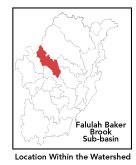
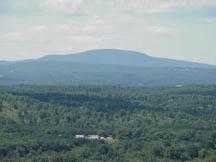
This subbasin1
predominantly lies in the community of Fitchburg, with
a portion in Ashby and Lunenburg, and a very small part
extending into Ashburnham. Located in the "fuzzy"
zone straddling the Worcester Plateau and Southern New
England Coastal Plains ecoregions2
of central Massachusetts, this area drains southeasterly
into the North Nashua River just upstream of the Fitchburg
Municipal Airport and the East Fitchburg Wastewater
Treatment Facility. Falulah Brook begins at Fitchburg
Reservoir in Ashby with various unnamed feeder streams
and is impounded behind Lovell Reservoir and Falulah
Reservoir, which is itself feed by Scott Reservoir via
Scott Brook. It flows southeasterly through the City
of Fitchburg paralleling the commercial strip of John
Fitch Highway where it is affected by urban influences
(and where it most affects the human population by periodically
flooding). Route 31 travels through the center of this
subbasin and Routes 2A and 13 pass through a portion
as well.
Streamflow, as in most of New England,
has significant seasonal changes3.
Pearl Hill and "Saima" Brooks are feeder streams
to Falulah-Baker Brook. This subbasin begins at higher
elevations in Ashby and Ashburnham (namely Jewell and
Blood Hills and Russell Hill respectively) then descends
toward the North Nashua River valley and floodplains.
The two highest points in this subbasin in Fitchburg
are Brown Hill in the west and Pearl Hill in the east.
There is a considerable swath of protected watershed
supply lands in the headwaters. The eastern and western
boundaries of this subbasin are north-south running
ridgelines and a third such similar ridgeline runs from
Blood Hill by Fitchburg Reservoir to Saima Park.
back
to top
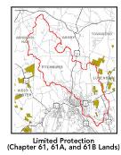
Land Ownership
and Land Use4
Patterns: The land-use pattern
is predominantly forest (hardwood mixed with softwood)
or wetland. Low-density residential settlement as well
as concentrated settlements and strip development along
major roads and in subdivisions account for residential.
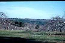
There is a fair amount of agriculture and/or open land
- approximately 5% of total land area -- notably the
Hertel and Marshall Agricultural Protection Restricted
(APR) farms in Fitchburg. However, part of the Marshall
Farm and Orchard is in the process of being converted
to a residential subdivision and the 330-acre ArnHow
Farm (in the northeastern section of this subbasin)
in anticipation of conversion to other uses has been
removed from the Chapter 61A program, which offered
limited protection of the land. Commercial operations,
industry and other developed land uses are numerous
and include densely-populated, highly urbanized areas
in with large paved areas (i.e. Wal-Mart shopping center).
With 11.3% of total impervious surfaces5
-- namely, paved areas such as streets, driveways, and
parking lots -- for this subbasin indicates that concerns
of compromised stormwater and other non-point sources
of contaminants (for example: pesticides, fertilizers,
oils, asphalt, pet wastes, salt, sediment, litter and
other debris) are not an immediate pressing concern.
Primary pollutants of concern in
stormwater are suspended solids, nutrients, metals,
oil and grease (PAH), temperature and bacteria. The
sources of bacteria in urban settings are typically
human and other animal litter left on driveways, lawns,
commercial and residential streets, parking lots and
rooftops.
Indeed, a shoreline survey of the
"Saima" Brook conducted by the Fitchburg Stream
Team in the Summer of 2001 noted sections that were
impacted by recent roadway construction and other development
activities. For the past two years the Fitchburg Stream
Team also participated in cleanups of Falulah Brook
(from its intersection with Route 2A to behind the John
Fitch Highway shopping center). Many tons of trash was
removed from the brook on both occasions: this stretch
of the brook clearly receives the most direct abuse.
Other groups have planned cleanups for the Coolidge
Park section of Falulah Brook.
back
to top
Major
Water Resource Issues: There
are neither any wastewater treatment facilities, NPDES*
permits, nor WMA* water withdrawal permits in this subbasin.
Much of the area underlying Bakers Brook is classified
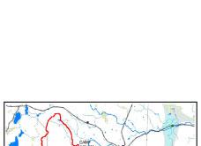
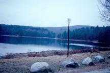
as a medium- and high-yield aquifer. Major waterbodies
in this subbasin include: Falulah, Fitchburg, Lovell,
and Scott Reservoirs; and Greenes, Paige and Putnam's
Ponds. The latter two contain noxious and non-native
plants. Feeder streams to Falulah Brook include various
unnamed ones, a so-called "Saima" Brook which
flows into Saima Pond and then Greenes Pond, and Pearl
Hill Brook which runs through Paige Pond. Indeed, the
official beginning of Bakers Brook is at the confluence
of Falulah and Pearl Hill Brooks (behind a shopping
center on John Fitch Highway).
During wet weather, the East Fitchburg
WWTP is permitted to discharge storm water and wastewater
from several combined sewer overflows (CSOs) to Baker
Brook and several unnamed streams. EPA issued an Administrative
Order in July 1996 requiring the city to develop a long-term
CSO control plan. The city submitted a Draft Plan and
Sewer Separation Study in January 1999 and additional
financial information in March 2000. This plan is currently
under review but has not been approved.
back
to top
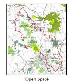
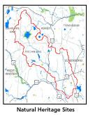
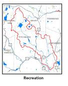
Recreation
and Priority Habitat Areas: The
recent municipal purchase of 170 acres of Blood Hill
in Ashby in the year 2001 for conservation purposes
must be considered a major open space acquisition. Coolidge
Park is a popular local recreation destination, which
is prominent in being very close to densely populated
Fitchburg neighborhoods. Saima Park -- a private recreation
area started by the Finnish community -- receives some
use while nearby municipally-owned Greenes Pond Conservation
Area is underutilized due to lack of trails. The Massachusetts
Audubon Society owns a several hundred acre property
in this subbasin, Flat Rocks Sanctuary, where there
is at least one certified vernal pool. Fitchburg Reservoir
is a MA Natural Heritage and Endangered Species Program
(NHESP) Priority Habitat site and an important bird
habitat, where common loons regularly nest.
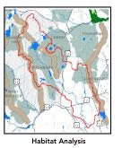
The one core area identified in
the Nashua River Habitat Assessment Report 2000,
which encompasses a large part of the northwestern end
of this subbasin, is called the Squannacook Headwaters.
The one habitat protection focus area in this subbasin
is Pearl Hill Brook, which is an important buffer between
Willard Brook State Forest and the urban development
of Fitchburg. Protection priorities include the entire
unprotected section south of Fitchburg Reservoir, which
includes narrow wetlands with adjacent uplands, and
the undeveloped portions of Maplewood Golf Course.
back
to top
Resource
Protection Goals and Recommended Actions
GOAL: Protect wildlife
habitat and migration corridors in the subbasin.
___Sponsor local events
to raise public understanding about native wildlife
and the impacts of development patterns on ecosystem
and habitat integrity.
___Work with local
conservation commissions to gain their backing of natural
resource and habitat inventories.
GOAL: Protect high-priority
open space, vistas, and community character in the subbasin.
___Encourage the use
of MA Executive Order 418* funding for Open Space and
Resource Protection Plans for each Massachusetts community
in this subbasin.
___Conduct public education
sessions to promote local passage of Community Preservation
Act*.
___Work toward ideal
of at least 25-50% protected open space in each municipality.
Determine which Chapter 61, 61A and 61B properties to
pursue Right of First Refusal* options on if the opportunity
arises.
___Work with municipal
officials to develop subdivision standards that require
proponents to devote at least 50% of land (not including
already undevelopable wet or steep land) for open space
conservation and encourage mixed-use development and
cluster zoning by-right bylaws.
GOAL: Increase recreational
opportunities throughout the subbasin.
___Support completion
of City of Fitchburg's Open Space and Recreation Plan.
Help implement its Five-Year Action Items. Apply for
Division of Conservation Services Self-Help* funds for
appropriate properties.
___Educate the public
and municipal departments (especially Public Works Depts)
on efforts relating to invasive species identification
and removal.
GOAL: Improve water
quality in the subbasin.
___ Assist Fitchburg
and Leominster with its Clean Water Act-mandated MS-4
Phase II Stormwater requirements.* These municipalities
will be required to obtain permits to reduce impacts
to the receiving streams through the development of
Best Management Practices (BMPs)*, elimination of cross-connections
and significant public education. CSO controls and the
development of a long-range control plan will be required.
___Help develop and
disseminate Best Management Practices for small-scale,
hobby type agricultural operations.
___ Determine locations
of combined sewer overflows (CSOs) in Fitchburg. Continue
to track progress of CSO abatement activities. Conduct
additional dry and wet weather fecal coliform bacteria
monitoring in most impacted segments of Baker Brook
to identify potential sources of pathogens and other
contaminants
___Survey invasive
plant infestation and conduct spot treatment to control
spread on Greenes and Putnam Ponds.
___Review the turf
maintenance practices of the area golf courses up gradient
of Pearl Hill Brook to determine potential non-point
source pollution from fertilizer use.
___Inventory, monitor
and improve stormwater drainage structures.
___Identify underground
storage tanks (USTs) and work to have them removed.
GOAL: Reduce negative
effects of development in this subbasin.
___ Help local volunteer
board members responsible for development and land-use
rulemaking and enforcement get technical assistance
and information regarding techniques to control/guide
land use and development balanced with adequate resource
protection (e.g., Citizens Planner Training Collaborative6
workshop offerings).
___Increase or establish staff hours
of municipal conservation agents to more effectively
monitor construction sites runoff and assist with the
preparation of bylaws such as erosion-sedimentation
controls.
back to top
*
|