|
Geographic
Overview and Ecosystem Characteristics:
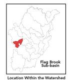
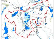
This subbasin1
primarily lies in the community of Westminster with a part in Fitchburg
and Princeton and a very small part extending into Leominster. Located
in the "fuzzy" zone straddling the Worcester Plateau and
Southern New England Coastal Plains ecoregions2
of central Massachusetts, this area drains northeasterly into the
North Nashua River by the West Fitchburg Wastewater Treatment Facility
at the intersection with the Whitman River below Snows Mill Pond.
Indeed, the North Nashua River begins at the confluence of Whitman
River and Flag Brook. Route 2 travels through the northern section
of this subbasin and Routes 31 and 140 pass through a portion as
well.
Streamflow, as in most of New England, has significant
seasonal changes3.
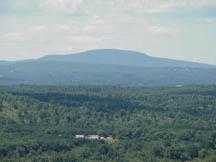
This subbasin begins at higher elevations in Westminster, most notably
Mt. Wachusett, which forms a semi-circular ridge along this subbasin's
southern divide. Another two prominent ridgelines reach off of the
Worcester Plateau providing upland connections to other nearby habitat
focus areas: Snow Hill-Crow Hills to Mt. Wachusett and Palmer Hill-Ball
Hill (which forms the eastern divide of this subbasin) to the Wekepeke.
back to top
Land Ownership and
Land Use4
Patterns: The land-use pattern is 71%
forest (hardwood mixed with softwood) or wetland. Low-density residential
settlement as well as concentrated settlements and strip development
located near town centers and along major roads account for a total
of 10% residential. Notably, 7% of the total land area is water.
Commercial operations, industry and other developed land uses are
not significant. The Fitchburg Municipal Landfill located in Westminster
(and abutting the Leominster State Forest on three sides) is scheduled
to soon roughly double in size. This landfill, operated by Waste
Management Inc.,serves a state-wide if not regional function. In
its former unlined construction, it most likely has negatively impacted
Flag Brook as its drainage ponds discharged into this waterway.
Though there may be other temporary environmental consequences of
expansion, especially during blasting/excavation phases, the new
lined design should be benign from a water quality standpoint.
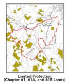
A substantial percentage of this subbasin is owned
by the state Department of Environmental Management in Wachusett
Mountain State Reservation and Leominster State Forest. Another
large percentage is designated municipal water supply land. A low
percentage (8%) of total impervious surfaces5
-- namely, paved areas such as streets, driveways, and parking lots
-- for this subbasin indicates that issues of compromised stormwater
and other non-point sources of contaminants (for example: pesticides,
fertilizers, oils, asphalt, pet wastes, salt, sediment, litter and
other debris) are not a pressing concern.
back to top
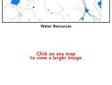
Major Water Resource
Issues: A large high- and medium-yield
aquifer runs north-south through the center of this subbasin underlying
the Wyman/Grassy Ponds-Wachusett Lake area. Major waterbodies in
this subbasin include: Crow Hill, Meetinghouse, Oak Hill, Rice Meadow,
Saw Mill, and Wyman/Grassy Ponds, and Wachusett Lake. Saw Mill and
Upper Crow Hill Ponds6
are considered eutrophic and contain noxious and non-native plants.
Flag Brook proper is classified as a Class B waterbody. In this
subbasin there are no wastewater treatment facilities and two water
withdrawal permitees: Wachusett Mountain Associates -- registered
to withdraw 0.23 MGD of surface and groundwater - and Custom Papers
Group registered to withdraw 1.6 MGD of surface water from Sawmill
Pond.
Based on recent findings in an Hydrologic Analysis
(inflow/outflow) by Camp, Dresser, Mckee, under contract with EOEA
for the Massachusetts Watershed Initiative Nashua Team, the Flag
Brook sub-basin is currently under a high level of stress, and will
continue a high level of stress into 2020. This means that the net
average August outflow from the sub-basin equals or exceeds the
estimated natural August average flow.
It is important to note that this area, which is predicted
to have some form of stress also contains multi-month reservoirs.
These reservoirs are capable of storing large flows in the spring
and holding them for use during low flow periods in late summer.
Because of the stored volume, the impact of large demands in these
basins may not be as great as the stress-classification system implies;
it is possible that normal low flows are still being released from
these reservoirs. To properly determine the stress levels in this
sub-basin, a more detailed study is required.
back to top
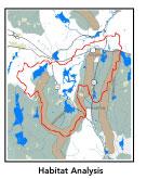
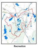
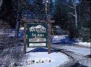
Recreation and
Priority Habitat Areas: Wachusett Mountain
Ski Area is the outstanding recreational destination in the subbasin
and is a state-wide resource. Nearly 5 miles of the long-distance
Mid-state Trail passes through this subbasin; although it may be
noted that there are no trail easements thereon. Perhaps the best
example of an acidic talus slope in the entire Nashua River watershed
is found at base of cliffs on the eastern slope of Crow Hills, which
is a well-known and heavily frequented climbing site.
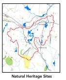
There is one state-designated Natural Heritage
and Endangered Species Project (MA NHESP) Rare Wetlands Priority
Habitat area centered on an unnamed tributary running toward Wyman
Pond off the northwest slope of Mt. Wachusett. There are two MA
NHESP Rare Wetlands priority sites: one at the same area as the
one above and another covering the summit of Mt. Wachusett. There
are two Jeff Collins identified core areas which encompass parts
of this subbasin: 1) Wachusett Mountain and 2) Notown Reservoir.
Wachusett Mountain, where a significant percentage of Massachusett's
total old-growth forest acreage is located, is considered to be
of Moderate Biodiversity Significance and an Exemplary Natural Community
among MA NHESP Priority Sites. Notown Reservoir core area is a part
of Leominster State Forest Habitat Protection focus area, which
is a crucial piece of any effort to maintain core wildlife habitat
in the watershed, and thus, should be one of the highest priorities
for concerted land protection in the watershed. Protection priorities
should be the west and southwestern slopes of Crow Hills and the
Flag Brook area north of the Leominster State Forest.
back to top
Resource Protection
Goals and Recommended Actions
GOAL: Protect wildlife habitat
and migration corridors in the subbasin.
- Monitor development activities in the area between
Saw Mill Pond and Notown Reservoir south of Route 2 and north
of the Leominster State Forest.
- Land protection efforts to focus on remaining undeveloped
shoreline on Saw Mill Pond in Fitchburg.
- Sponsor local events to raise public understanding
about native wildlife and the impacts of development patterns
on ecosystem and habitat integrity.
- Work with local conservation commissions to gain
their backing of natural resource and habitat inventories.
GOAL: Protect high-priority open space, vistas,
and community character in the subbasin.
- Encourage the use of MA Executive Order 418*
funding for Open Space and Resource Protection Plans for each
Massachusetts community in the Flag Brook subbasin.
- Conduct public education sessions to promote local
passage of Community Preservation Act*.
- Work toward ideal of at least 25-50% protected
open space in each municipality.
- Work with municipal officials to develop subdivision
standards that require proponents to devote at least 50% of land
(not including already undevelopable wet or steep land) for open
space conservation and encourage mixed-use development and cluster
zoning by-right bylaws.
GOAL: Increase recreational opportunities throughout
the subbasin.
- Work toward securing trail easements on sections
of the Mid-state Trail.
- Improve canoeing, fishing, and swimming opportunities
by removing weeds from lakes.
- Educate the public and municipal departments (especially
Public Works Depts.) on efforts relating to invasive species identification
and removal.
GOAL: Improve water quality in the subbasin.
- Assist Fitchburg with its Clean Water Act-mandated
MS-4 Phase II Stormwater requirements*
This municipality will be required to obtain permits to reduce
impacts to the receiving streams through the development of Best
Management Practices (BMPs)*,
elimination of cross-connections and significant public education.
CSO controls and the development of a long-range control plan
will be required.
- Help develop and disseminate Best Management Practices
for small-scale, hobby type agricultural operations.
- Monitor Fitchburg Municipal Landfill expansion
for compliance with leachate management.
- Survey invasive plant infestation and conduct spot
treatment to conduct spread in Saw Mill and Upper Crow Hill Ponds.
- Identify Water Management Act (WMA)*
withdrawals in the Flag Brook subwatershed. Evaluate compliance
with registration and/or permit limits.
- Identify the degree of threat from potential faulty/
illicitly discharging septic systems, which may result in bacterial
and nutrient contamination of nearby streams and groundwater.
- Identify underground storage tanks (USTs) and work
to have them removed.
GOAL: Reduce negative effects of development in
this subbasin.
- Help local volunteer board members responsible
for development and land-use rulemaking and enforcement get technical
assistance and information regarding techniques to control/guide
land use and development balanced with adequate resource protection
(e.g., Citizens Planner Training Collaborative7
workshop offerings).
- Increase or establish staff hours of municipal
conservation agents to more effectively monitor construction sites
runoff and assist with the preparation of bylaws such as erosion-sedimentation
controls.
back to top
*
glossary.
|