|
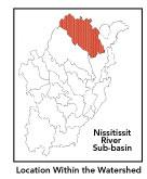
Geographic
Overview and Ecosystem Characteristics:
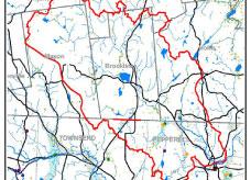
Located in the "fuzzy" zone of Southern
New England Coastal Plains and Hills ecoregion1
of north central Massachusetts
and southern New Hampshire, this area drains southeasterly
into the main stem Nashua River just north of
Pepperell center. The Massachusetts communities
of Pepperell and Townsend lie wholly or partially
within the Nissitissit subbasin as do the New
Hampshire communities of Brookline, Hollis, Mason,
and Milford. The topography ranges from "upland
plateaus" in the headwater section to more
gently rolling, hilly terrain to generally flat
"coastal plain" lowland river valleys
in the southeast.
Designated
an Outstanding Resource Waters (ORW) in Massachusetts,
the Nissitissit River is a high value aquatic
riverine ecosystem with high aesthetic quality
and great wildlife habitat. Further, the subbasin
has the distinction of being the focus of the
Squannacook-Nissitissit Rivers Sanctuary Act (MGL
132A:17) passed in 1975 and intended to protect
the ORWs of these two river basins from degradation
by new discharges of pollution. Streamflow, as
in most of New England, has significant seasonal
changes.
Largely because
its headwaters tributary streams drain an area
that is heavily forested and little developed
— namely, the Badger Hill/Spaulding Brook
area in Brookline and Mason, New Hampshire and
the Townsend State Forest in Massachusetts —
the main stem of the Nissitissit River is a cold,
clean, well-oxygenated stream that is frequently
cited as prime habitat for native brook trout
and five listed rare species. Important habitat
areas include: Townsend State Forest, Gulf Brook,
Heald Pond, Townsend Hill, Nissitissit Hills,
Kimball Farm, and Bancroft Brook Headwaters. Sucker
Brook is a cold-water fishery containing native
Eastern Brook Trout and is stocked with trout
as is Gulf Brook. Mine Brook is also a cold-water
fishery.
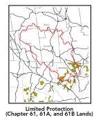
Due to conservation efforts,
nearly 50% of the entire length of the Nissitissit
River has a 300 foot vegetated buffer strip. There
is particularly strong land protection focus in
Brookline, NH.
Indeed, given its high quality there is consideration
of designating New Hampshire Scenic Status to
the Nissitissit River.
back
to top
Land
Ownership and Land Use2
Patterns: The land-use
pattern is concentrated settlements and strip
development with much of the sub-basin little
developed and containing areas of privately owned
open spaces as well as a small percentage of protected
land in Beaver Brook Association, Townsend State
Forest, the Nissitissit River Wildlife Management
Area, and municipal or state holdings. The geographic
area is experiencing elevated and considerable
residential development pressure and land use
change (forest fragmentation, loss of agricultural
fields). Low percentage (less than 8%)3
of total impervious surfaces - namely, paved areas
such as streets, driveways, parking lots -- for
this whole subbasin indicates that concerns of
compromised stormwater and other non-point sources4
of contaminants (for example: pesticides, fertilizers,
oils, asphalt, pet wastes, salt, sediment, litter
and other debris) is not a pressing concern.
back
to top
Major
Water Resource Issues: This
sub-basin as a whole contains important headwaters
and high quality groundwater that are under intense
development pressure which poses a threat to the
future quantity and quality of the resource. As
for other issues and
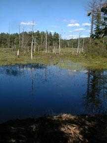
areas warranting attention, Heald Pond is in an
eutrophic state and contains noxious plants. Invasive
weed infestation on Lake Potanapo needs to be
addressed: indeed, various alternatives are presently
being considered by the Brookline Conservation
Commission and others. According to the 1998 Nashua
River Watershed Report Card, the Nissitissit River
below the impoundment is rated as partially supportive
of biology.5
back
to top
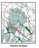
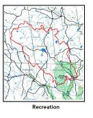
Recreation
and Priority Habitat Areas: Largely
because its headwaters and tributary streams drain
an area that is heavily forested and little developed—namely,
the Badger Hill/Spaulding Brook area in Brookline
and Mason, New Hampshire and the Townsend State
Forest in Massachusetts — the main stem of
the Nissitissit River is a cold, clean, well-oxygenated
stream that is frequently cited as prime habitat
for native brook trout.
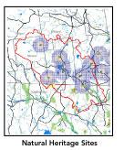
The entire length of the Nissitissit
in Massachusetts is identified as Natural Heritage
Priority Habitat for five listed species. Indeed,
55% of this subbasin (in the Massachusetts portion)
is considered to be a Natural Heritage and Endangered
Species Project (MA NHESP) BioMap core or supporting
area (37% and 18% respectively).
Sucker Brook supports Native
Eastern Brook Trout as well as stocked trout.
Gulf Brook in Townsend is a cold-water fishery
and is also stocked with trout. Mine Brook is
a cold water fishery (and there is no data on
another major tributary, Beaver Brook). The Nissitissit,
like the Squannacook River, is identified by aquatic
biologists, anglers, entomologists, and land protection
professionals as one of the highest quality stretches
of aquatic habitat in the watershed. Important
habitat areas include: Townsend State Forest,
Gulf Brook, Heald Pond, Townsend Hill, Nissitissit
Hills, Kimball Farm, and Bancroft Brook Headwaters.
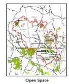
In particular, conservation
of riverfront lands is highly important, as a
riverine "greenway" acts as a vegetated
buffer to protect water quality and wildlife habitat,
to prevent flood damage, and to provide outstanding
recreation opportunities. Due to conservation
efforts, nearly 50% of the entire length of the
Nissitissit River has a 300 foot vegetated buffer
strip. There is particularly strong land protection
focus in Brookline, NH. Indeed, given its high
quality there is consideration of designating
New Hampshire Scenic River Status to the Nissitissit
River. Over 70% of this subbasin (in the Massachusetts
portion) falls within the proposed Squannassit
Area of Critical Environmental Concern (ACEC)
nomination.
back
to top
Resource
Protection Goals and Recommended Actions
GOAL: Protect
wildlife habitat and migration corridors in the
subbasin.
- Land protection efforts to focus
on: Sucker Brook, Heald Pond, Coon Tree Pond,
and Gulf Brook; and, most importantly, the Belmont
Spring aquifer area: in the latter case, establish
a proactive committee to pursue negotiations
with the landowners.
- Sponsor local events to raise
public understanding about native wildlife and
the impacts of development patterns on ecosystem
and habitat integrity.
- Work with local conservation
commissions to gain their backing of natural
resource and habitat inventories.
GOAL: Protect high-priority open
space, vistas, and community character in the
subbasin.
- Encourage the use of MA Executive
Order 418*
funding for Open Space and Resource Protection
Plans for each Massachusetts community in the
Nissitissit subbasin.
- Conduct public education sessions
to promote local passage of Community Preservation
Act*.
- Work toward ideal of at least
25-50% protected open space in each municipality.
- Work with municipal officials
to develop subdivision standards that require
proponents to devote at least 50% of land (not
including already undevelopable wet or steep
land) for open space conservation and encourage
mixed-use development and cluster zoning by-right
bylaws.
- Support efforts of the Squannassit
Regional Reserve Initiative*
(facilitated by the NRWA) and the Squannassit
ACEC nomination which encompasses much of this
subbasin.
- Encourage municipalities to adopt
and enforce "Scenic River Protection"
type bylaws*
(similar to Townsend's river protection bylaw).
GOAL: Increase recreational opportunities
throughout the subbasin.
- Improve canoeing, fishing, and
swimming opportunities by removing weeds from
water bodies.
- Educate the public and municipal
departments (especially Public Works Depts.)
on efforts relating to invasive species identification
and removal.
GOAL: Improve water quality in
the subbasin.
- Support source
water protection efforts of local communities,
land trusts, and water suppliers.
- Extend the Squannacook-Nissitissit
Sanctuary Act* into
the New Hampshire portion of the watershed.
- Identify the major sources of
phosphate inputs to the river and work with
communities to address the problem.
- Assess and eliminate contamination
of surface and ground water caused by human
activities.
- Identify the degree of threat
from potential faulty/ illicitly discharging
septic systems, which may result in bacterial
and nutrient contamination of nearby streams
and groundwater.
- Inventory, monitor and improve
stormwater drainage structures.
- Identify underground storage
tanks (USTs) and work to have them removed.
GOAL: Reduce negative effects
of development in this subbasin.
- Help local volunteer board members
responsible for development and land-use rulemaking
and enforcement get technical assistance and
information regarding techniques to control/guide
land use and development balanced with adequate
resource protection (e.g., Citizens Planner
Training Collaborative6 workshop offerings).
- Monitor increased imperviousness,
both direct and indirect riparian zone alterations,
and uncontrolled runoff from construction sites
to prevent increased stream temperature and
sedimentation through macroinvertebrate sampling
performed by volunteer stream team monitors.
- Increase or establish staff
hours of municipal conservation agents to more
effectively monitor construction sites runoff
and assist with the preparation of bylaws such
as erosion-sedimentation controls.
back
to top
.
|