|
Geographic
Overview and Ecosystem Characteristics:
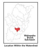
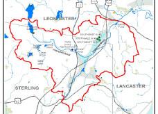
Most of this subbasin1primarily
lies in the municipality of Sterling with parts extending into Leominster
and Lancaster. Located in the Southern New England Coastal Hills
and Plains ecoregion2
of central Massachusetts, this area drains into the North Nashua
River in Lancaster just below Bartletts Pond. Streamflow, as in
most of New England, has significant seasonal changes3.
Topography is generally hilly, encompassing numerous wetlands, broad
valleys, and floodplains.
back to top
Land Ownership and
Land Use4
Patterns: The land-use pattern is predominantly
rural, undeveloped forest (hardwood mixed with softwood) or wetland
plus low-density residential settlement in the hilly upland areas.
Concentrated settlements and strip developments are located near
town centers and along major roads. Heavily traveled Interstate
190 runs through this subbasin. The highway, which connects Worcester
and Leominster, has led to and will continue to lead to increased
development pressures, primarily of single-family residences. Agriculture
(notably "hobby farms" and backyard horse paddocks), commercial
operations, industry and other developed land uses are less significant.
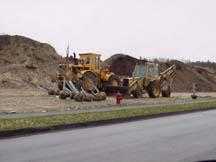
However, sand and gravel extraction operations are contributing
to sedimentation and land use change.
A low percentage (less than 10%) of total impervious
surfaces5
— namely, paved areas such as streets, driveways, and parking
lots — for this whole subbasin indicates that concerns of compromised
stormwater and other non-point sources of contaminants (i.e.: pesticides,
oils, fertilizers, asphalt, pet wastes, salt, sediment, litter and
other debris) are not a pressing issue.
back to top
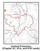
Major Water Resource
Issues: The amount of permanently protected
undeveloped open space and undeveloped woodland in the subbasin
has meant that the water quality in the subbasin remains high. This
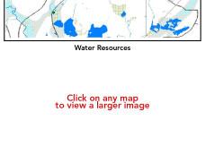
subbasin features a network of unnamed streams and swamps. Wekepeke
Brook in Sterling is one of the best coldwater streams in Eastern
Massachusetts. It has good tree cover for shading to maintain cold
water temperature, has high fertility and moderate acidity and,
consequently, self-supporting populations of brook and brown trout.
The headwaters of Wekepeke Brook drain to five reservoirs: Heywood
Reservoir, Fitch Basin, Spring Basin, and Upper and Lower Lynde
Basins (which are fed by Lynde Brook). At times in the past, Lynde
Basin has been noted to be eutrophic.
Sterling's Municipal Wells # 2, 4 and 5, the
Wekepeke Aquifer, and Leominster's Zone III Area of Protection face
possible contamination sources. These include Sterling's landfill
in the recharge area, pesticide use in power line and railroad Rights
of Ways, and beavers which have capitalized on the present environmental
conditions and proliferated to the point of being considered a "nuisance"
species*.
The most serious damage beavers are causing in this subbasin, in
addition to increased localized flooding behind their dams, is from
bacterial contamination of wellwater. Additionally, there is concern
of potential negative impact on Wekepeke Brook from potential increased
aquifer withdrawals. Also, any further development of the Wekepeke
Aquifer - from residential septic systems and farming operations
could affect the Town of Lancaster's well near the North Nashua
River. Note that Lancaster does have a Water Supply Protection District
By-law.
Based on recent findings in an Hydrologic Analysis
(inflow/outflow) by Camp, Dresser, Mckee, under contract with EOEA
for the Massachusetts Watershed Initiative Nashua Team, the Wekepeke
sub-basin is currently under a medium level of stress. Looking ahead
to the year 2020, Wekepeke Brook remains under a medium level of
stress. This means that the net 7Q10 outflow from the sub-basin
equals or exceeds the estimated natural 7Q10. 7Q10 is the lowest
consecutive 7 day streamflow that is likely to occur in a ten year
period in a particular river segment.
back to top
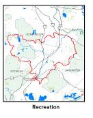
Recreation and
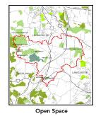
Priority Habitat Areas: The recent municipal
purchase of the Sholan Farm in Leominster in the year 2001 for conservation
and watershed protection purposes is considered a major open space
acquisition. Another significant conservation project recently completed
in the subbasin is the purchase of part of Ballard Hill in Lancaster
by the Trustees of Reservations. The Town of Clinton has owned considerable
acreage in the "Wekepeke" Reservoirs area for one and
half centuries. At one time, Clinton utilized this source as a potable
public water supply until 1964 when it was removed from service
as the MDC's Wachusett Reservoir proved to be a more attractive
long-term supply. Clinton is in the process of placing a conservation
restriction — in partnership with the state — on this
"Waterworks" land, which it holds as a reserve. Permanent
development restrictions of this area will greatly contribute to
the continued protection of the Wekepeke surface and groundwater
resources.
Bartlett Pond Conservation Area in Lancaster
off Route 117 and the Lancaster Town Forest are local recreational
destinations. The Allen Agricultural Protection Restriction (APR)
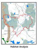
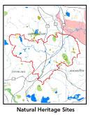
in Sterling is several hundred acres. There are three MA Natural
Heritage and Endangered Species Program (NHESP) Priority Habitat
sites in this subbasin:
- in the vicinity of an unnamed stream draining
north, crossing at the intersection of Flanagan Hill, Hilltop,
and Brockelman Roads;
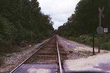
- Heywood Reservoir; and, 3) along the Conrail
line south of Route 117 between Route 12 and I-190.
There are three habitat areas identified in
the Nashua River Habitat Assessment Report (MAS, 2000):
1) the Ballard Hill area;
2) the Wekepeke Brook area; and,
3) a small portion of the western part
of this subbasin falls within the Leominster State Forest/ Notown
Reservoir core habitat area.
Protection priorities should focus on unprotected
lands adjacent to Wekepeke Brook. The NHESP BioMap data supports
the both the Nashua River Habitat Assessment Report and the NHESP
Priority Habitat information cited above.
back to top
Resource Protection
Goals and Recommended Actions
GOAL: Protect wildlife habitat
and migration corridors in the subbasin.
- Sponsor local events to raise public understanding
about native wildlife and the impacts of development patterns
on ecosystem and habitat integrity.
- Work with local conservation commissions to gain
their backing of natural resource and habitat inventories.
GOAL: Protect high-priority open space, vistas,
and community character in the subbasin.
- Encourage the use of MA Executive Order 418*
funding for Open Space and Resource Protection Plans for each
Massachusetts community in this subbasin.
- Conduct public education sessions to promote local
passage of Community Preservation Act*
- Work toward ideal of at least 25-50% protected
open space in each municipality.
- Work with municipal officials to develop subdivision
standards that require proponents to devote at least 50% of land
(not including already undevelopable wet or steep land) for open
space conservation and encourage mixed-use development and cluster
zoning by-right bylaws.
- Encourage municipalities to adopt and enforce "Scenic
River Protection" type bylaws.*
GOAL: Improve water quality in the subbasin.
- Assist Leominster with its Clean Water Act-mandated
MS-4 Phase II Stormwater requirements.*
This municipality will be required to obtain permits to reduce
impacts to the receiving streams through the development of Best
Management Practices (BMPs)*,
elimination of cross-connections and significant public education.
CSO controls and the development of a long-range control plan
will be required.
- Help develop and disseminate Best Management Practices
for small-scale, hobby type agricultural operations.
- Develop and implement comprehensive regional wellhead
protection program.
- Monitor Sterling's Pratt's Junction Road light
industrial zone.
- Monitor Volatile Organic Chlorine (VOC) readings
in Leominster's water.
- Monitor Jungle Road industrial area in Leominster.
- Identify Water Management Act (WMA)*
withdrawals in the Wekepeke subbasin. Evaluate compliance with
registration and/or permit limits. Determine potential impacts
of withdrawals on streamflow/habitat.
- Identify the degree of threat from potential faulty/
illicitly discharging septic systems, which may result in bacterial
and nutrient contamination of nearby streams and groundwater.
- Inventory, monitor and improve stormwater drainage
structures.
- Identify underground storage tanks (USTs) and work
to have them removed.
GOAL: Reduce potential negative effects of some
development in this subbasin.
- Review the turf maintenance practices of are golf
courses to determine potential non-point source pollution from
fertilizer use.
- Help local volunteer board members responsible
for development and land-use rulemaking and enforcement get technical
assistance and information regarding techniques to control/guide
land use and development balanced with adequate resource protection
(e.g., Citizens Planner Training Collaborative6
workshop offerings).
- Monitor increased imperviousness, both direct and
indirect riparian zone alterations, and uncontrolled runoff from
construction sites to prevent increased stream temperature and
sedimentation through macroinvertebrate sampling performed by
volunteer stream team monitors.
- Increase or establish staff hours of municipal
conservation agents to more effectively monitor construction sites
runoff and assist with the preparation of bylaws such as erosion-sedimentation
controls.
back to top
.
|